
FCCInfo.com
A Service of Cavell, Mertz & Associates, Inc.
(855) FCC-INFO
|
|
|
|  |
|
|||||||||||||||
|
|
WPAT-FM Channel: 226B 93.1 MHz Paterson, New Jersey Service: FS - A full service FM station auxiliary transmitting antenna or application. Facility ID: 51663 Fac. Service: FM Status: Construction Permit Application Accepted: 12/14/2022 Application Granted: 01/24/2023 File Number: -0000205129 WPAT-FM CP Expires: 01/24/2026 Application Type: Construction Permit FCC Website Links: LMS Facility Details This Application Other WPAT-FM Applications Other WPAT-FM Applications in CDBS Including Superseded Applications Mailing Address Correspondence for WPAT-FM Correspondence related to application -0000205129 Service Contour - Open Street Map or USGS Map (54 dBu) Service Contour - KML / Google Earth (54 dBu) Public Inspection Files History Cards for WPAT-FM Facility Type: FM STATION Class: B, A Zone I or I-A station; with 25kW-50kW ERP and a class contour distance 39km-52km Site Location: 40-57-39.0 N 73-55-21.0 W (NAD 83) Site Location: 40-57-38.6 N 73-55-22.5 W (Converted to NAD 27) Effective Radiated Power: 10 kW Antenna Center HAAT: 231 m (758 ft.) Antenna Center AMSL: 271.5 m (891 ft.) Antenna Center HAG: 113 m (371 ft.) Site Elevation: 158.5 m. (520 ft.) Height Overall*: 129.6 m (425 ft.) (* As Filed In This Application, may differ from ASR Data, Below.) Directional Antenna Antenna Make/Model: None Antenna ID: 69-2019-08-06 Polarization:
| ||||||||||||||||||
| Antenna Data for Antenna Id: 69-2019-08-06 WPAT-FM FS File: -0000205129 None - Service: FS | 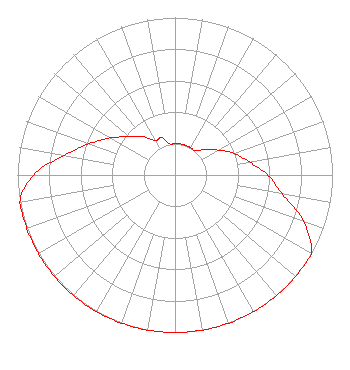 | ||||||||||||||||||
| Azimuth | Ratio | Azimuth | Ratio | Azimuth | Ratio | Azimuth | Ratio | ||||||||||||
| 0 | 0.200 | 10 | 0.200 | 20 | 0.200 | 30 | 0.200 | ||||||||||||
| 40 | 0.200 | 50 | 0.252 | 60 | 0.317 | 70 | 0.399 | ||||||||||||
| 80 | 0.480 | 90 | 0.590 | 100 | 0.690 | 110 | 0.869 | ||||||||||||
| 120 | 1.000 | 130 | 1.000 | 140 | 1.000 | 150 | 1.000 | ||||||||||||
| 160 | 1.000 | 170 | 1.000 | 180 | 1.000 | 190 | 1.000 | ||||||||||||
| 200 | 1.000 | 210 | 1.000 | 220 | 1.000 | 230 | 1.000 | ||||||||||||
| 240 | 1.000 | 250 | 1.000 | 260 | 1.000 | 270 | 0.900 | ||||||||||||
| 280 | 0.715 | 290 | 0.580 | 300 | 0.470 | 310 | 0.380 | ||||||||||||
| 320 | 0.317 | 330 | 0.252 | 340 | 0.252 | 350 | 0.200 | ||||||||||||
Structure Registration Number 1048672 Structure Type: TOWER Registered To: K2 Towers II, LLC Structure Address: Us Rt 9w Alpine, NJ County Name: Bergen County ASR Issued: 12/24/2019 Date Built: 05/22/2003 Site Elevation: 158.5 m (520 ft.) Structure Height: 121.9 m (400 ft.) Height Overall: 129.6 m (425 ft.) Overall Height AMSL: 288.1 m (945 ft.) FAA Determination: 06/03/2003 FAA Study #: 2001-AEA-3702-OE FAA Circular #: 70/7460-1K Paint & Light FAA Chapters: 3, 4, 5, 12 Removed expiration date from determination. Scenario 1./jjs/case#635066 40-57-39.0 N 73-55-21.0 W (NAD 83) 40-57-38.6 N 73-55-22.5 W (Converted to NAD 27) |
7007 Nw 77th Avenue Miami, FL 33166 Phone: 305-441-6901 Corporation | Title: Secretary Date: 12/14/2022 Application Certifier WPAT LICENSING, INC. Wpat Licensing, Inc. 7007 Nw 77th Avenue Miami, FL 33166 Applicant William J. Getz Carl T. Jones Corporation Carl T. Jones Corporation 7901 Yarnwood Ct Springfield, VA 22153 CONSULTING ENGINEER NANCY A. Ory Lerman Senter Pllc 2001 L Street, Nw, Suite 400 Washington, DC 20036 Attorney | |||||||||||||||||
| |||||||||||||||||||