
FCCInfo.com
A Service of Cavell, Mertz & Associates, Inc.
(855) FCC-INFO
|
|
W273EB from 12/30/2013 |
|
|
||||||||||||||||
|
|
W273EB Channel: 271D 102.1 MHz Shelton, Connecticut Service: FX - A translator or application for a translator. Facility ID: 156144 Fac. Service: FX Programming Delivery Method: Unspecified Status: Construction Permit Application Accepted: 01/11/2023 Application Granted: 01/26/2023 File Number: -0000206702 W273EB CP Expires: 01/25/2026 Application Type: Minor Modification FCC Website Links: LMS Facility Details This Application Other W273EB Applications Other W273EB Applications in CDBS Including Superseded Applications Mailing Address Correspondence for W273EB Correspondence related to application -0000206702 Service Contour - Open Street Map or USGS Map (60 dBu) Service Contour - KML / Google Earth (60 dBu) Facility Type: NON-COMMERCIAL EDUC. FM Class: D, A Noncommercial educational operating with no more than 10W Site Location: 41-16-44.3 N 73-11-06.4 W (NAD 83) Site Location: 41-16-44.0 N 73-11-08.0 W (Converted to NAD 27) Effective Radiated Power: 0.25 kW Antenna Center HAAT: 0 m Antenna Center AMSL: 223.5 m (733 ft.) Antenna Center HAG: 65 m (213 ft.) Site Elevation: 158.5 m. (520 ft.) Height Overall*: 151.2 m (496 ft.) (* As Filed In This Application, may differ from ASR Data, Below.) Directional Antenna Antenna Make/Model: Kathrein-Scala YA-7 Array Antenna ID: 122335 Polarization: H
| ||||||||||||||||||
| Antenna Data for Antenna Id: 122335 W273EB FX File: -0000206702 Kathrein-Scala - YA-7 Array Service: FX | 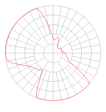 | ||||||||||||||||||
| Azimuth | Ratio | Azimuth | Ratio | Azimuth | Ratio | Azimuth | Ratio | ||||||||||||
| 0 | 0.300 | 10 | 0.290 | 20 | 0.340 | 30 | 0.200 | ||||||||||||
| 40 | 0.150 | 50 | 0.150 | 60 | 0.180 | 70 | 0.190 | ||||||||||||
| 80 | 0.190 | 90 | 0.250 | 100 | 0.280 | 110 | 0.330 | ||||||||||||
| 120 | 0.430 | 130 | 1.000 | 140 | 1.000 | 150 | 1.000 | ||||||||||||
| 160 | 1.000 | 170 | 1.000 | 180 | 1.000 | 190 | 1.000 | ||||||||||||
| 200 | 1.000 | 210 | 0.460 | 220 | 0.460 | 230 | 0.500 | ||||||||||||
| 240 | 0.560 | 250 | 0.720 | 260 | 0.950 | 270 | 1.000 | ||||||||||||
| 280 | 1.000 | 290 | 1.000 | 300 | 1.000 | 310 | 1.000 | ||||||||||||
| 320 | 1.000 | 330 | 1.000 | 340 | 1.000 | 350 | 0.600 | ||||||||||||
Structure Registration Number 1205267 Structure Type: GTOWER Registered To: Pinnacle Towers LLC Structure Address: Booth Hill Road Trumbull, CT County Name: Fairfield County ASR Issued: 09/01/2022 Date Built: 06/01/1953 Site Elevation: 158.5 m (520 ft.) Structure Height: 140.2 m (460 ft.) Height Overall: 151.2 m (496 ft.) Overall Height AMSL: 309.7 m (1016 ft.) FAA Determination: 11/05/2020 FAA Study #: 2020-ANE-6216-OE FAA Circular #: 70/7460-1L Paint & Light FAA Chapters: 4, 8, 12 PRIOR STUDY 2020-ANE-5789-OE 41-16-44.3 N 73-11-06.4 W (NAD 83) 41-16-44.0 N 73-11-08.0 W (Converted to NAD 27) |
5503 Sw 6th Ave Cape Coral, FL 33914 Phone: 203-762-9425 Limited Liability Company | Title: Operating Manager Date: 01/11/2023 Application Certifier SUN SIGNALS LLC Sun Signals Llc 5503 Sw 6th Ave Cape Coral, FL 33914 Applicant Dennis Jackson Sun Signals Llc 5503 Sw 6th Ave Cape Coral, FL 33914-7296 Operating Manager Dennis Jackson Sun Signals Llc 5503 Sw 6th Ave Cape Coral, FL 33914-7296 Operating Manager | |||||||||||||||||