
FCCInfo.com
A Service of Cavell, Mertz & Associates, Inc.
(855) FCC-INFO
|
|
K269GT from 10/27/2016 K269GT from 12/31/2013 |
|
|
||||||||||||||||
|
|
K269GT Channel: 269D 101.7 MHz Houston, Texas Service: FX - A translator or application for a translator. Facility ID: 141207 Fac. Service: FX Programming Delivery Method: Unspecified Status: License Application Accepted: 06/22/2021 Application Granted: 07/30/2021 File Number: -0000150750 License Expires: 08/01/2021 Application Type: License To Cover FCC Website Links: LMS Facility Details This Application Other K269GT Applications Other K269GT Applications in CDBS Including Superseded Applications Mailing Address Correspondence for K269GT Correspondence related to application -0000150750 Service Contour - Open Street Map or USGS Map (60 dBu) Service Contour - KML / Google Earth (60 dBu) Facility Type: FM STATION Class: D, A Noncommercial educational operating with no more than 10W Site Location: 29-53-42.7 N 95-26-20.6 W (NAD 83) Site Location: 29-53-41.9 N 95-26-19.8 W (Converted to NAD 27) Effective Radiated Power: 0.25 kW Transmitter Output Power: 0.078 kW Antenna Center HAAT: 0 m Antenna Center AMSL: 179.7 m (590 ft.) Antenna Center HAG: 152 m (499 ft.) Site Elevation: 27.7 m. (91 ft.) Height Overall*: 173.1 m (568 ft.) (* As Filed In This Application, may differ from ASR Data, Below.) Directional Antenna Antenna Make/Model: Scala CA5-FM Antenna ID: 134979 Polarization: H
| ||||||||||||||||||
| Antenna Data for Antenna Id: 134979 K269GT FX File: -0000150750 Scala - CA5-FM Service: FX | 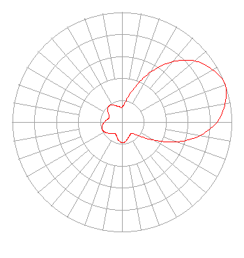 | ||||||||||||||||||
| Azimuth | Ratio | Azimuth | Ratio | Azimuth | Ratio | Azimuth | Ratio | ||||||||||||
| 0 | 0.134 | 10 | 0.190 | 20 | 0.329 | 30 | 0.528 | ||||||||||||
| 40 | 0.718 | 50 | 0.866 | 60 | 0.952 | 70 | 1.000 | ||||||||||||
| 80 | 0.952 | 90 | 0.866 | 100 | 0.718 | 110 | 0.528 | ||||||||||||
| 120 | 0.329 | 130 | 0.190 | 140 | 0.134 | 150 | 0.142 | ||||||||||||
| 160 | 0.157 | 170 | 0.181 | 180 | 0.187 | 190 | 0.171 | ||||||||||||
| 200 | 0.140 | 210 | 0.123 | 220 | 0.135 | 230 | 0.160 | ||||||||||||
| 240 | 0.182 | 250 | 0.193 | 260 | 0.182 | 270 | 0.160 | ||||||||||||
| 280 | 0.135 | 290 | 0.123 | 300 | 0.140 | 310 | 0.171 | ||||||||||||
| 320 | 0.187 | 330 | 0.181 | 340 | 0.157 | 350 | 0.142 | ||||||||||||
Structure Registration Number 1049572 Structure Type: GTOWER Registered To: American Towers LLC Structure Address: 2335 W Mount Houston Rd (stuebner Airline 1 #4273) Houston, TX County Name: Harris County ASR Issued: 05/11/2016 Date Built: 09/15/1986 Site Elevation: 27.7 m (91 ft.) Structure Height: 164.6 m (540 ft.) Height Overall: 173.1 m (568 ft.) Overall Height AMSL: 200.8 m (659 ft.) FAA Determination: 03/01/2016 FAA Study #: 2016-ASW-2188-OE FAA Circular #: 70/7460-1L Paint & Light FAA Chapters: 4, 8, 12 PRIOR STUDY 2007-ASW-4812-OE 29-53-42.7 N 95-26-20.6 W (NAD 83) 29-53-41.9 N 95-26-19.8 W (Converted to NAD 27) |
2625 Fm 1960 Road West Houston, TX 77068 Phone: 832-675-0238 Corporation | Title: President Date: 06/22/2021 Application Certifier KING BROADCASTING CORPORATION King Broadcasting Corporation 2625 Fm 1960 Road West Houston, TX 77068 Applicant Dan J Alpert The Law Office Of Dan J. Alpert 2120 N. 21st Rd. Arlington, VA 22201 Darryl K DeLawder, President Delawder Communications, Inc. Delawder Communications, Inc. P.o. Box 1095 Ashburn, VA 20146 ENGINEERING CONSULTANT | |||||||||||||||||