
FCCInfo.com
A Service of Cavell, Mertz & Associates, Inc.
(855) FCC-INFO
|
|
|
|
|
||||||||||||||||
|
|
WOTW Channel: 204A 88.7 MHz Lakewood, New Jersey Service: FM - A full-service FM station or application. Facility ID: 764260 Fac. Service: FM Status: Construction Permit Application Accepted: 12/23/2021 Application Granted: 02/24/2023 File Number: -0000167401 WOTW CP Expires: 02/24/2026 Application Type: Non-Commercial Educational Amendment FCC Website Links: LMS Facility Details This Application Other WOTW Applications Other WOTW Applications in CDBS Including Superseded Applications Mailing Address Correspondence for WOTW Correspondence related to application -0000167401 Service Contour - Open Street Map or USGS Map (60 dBu) Service Contour - KML / Google Earth (60 dBu) Public Inspection Files Facility Type: NON-COMMERCIAL EDUC. FM Class: A, A Zone I; I-A; or II station; with 0.1kW-6kW ERP and a class contour distance <=28km Site Location: 40-02-05.9 N 74-13-40.2 W (NAD 83) Site Location: 40-02-05.5 N 74-13-41.7 W (Converted to NAD 27) Effective Radiated Power: 0.001 kW Horiz. ; 0.5 kW Vert. Antenna Center HAAT: 34 m (112 ft.) Antenna Center AMSL: 52 m (171 ft.) Antenna Center HAG: 25 m (82 ft.) Site Elevation: 27.4 m. (90 ft.) Height Overall*: 41.1 m (135 ft.) (* As Filed In This Application, may differ from ASR Data, Below.) Directional Antenna Antenna Make/Model: None Antenna ID: 69-2019-08-06 Polarization: | ||||||||||||||||||
| Antenna Data for Antenna Id: 69-2019-08-06 WOTW FM File: -0000167401 None - Service: FM | 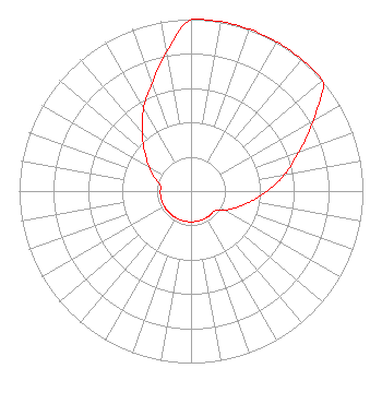 | ||||||||||||||||||
| Azimuth | Ratio | Azimuth | Ratio | Azimuth | Ratio | Azimuth | Ratio | ||||||||||||
| 0 | 1.000 | 10 | 1.000 | 20 | 1.000 | 30 | 1.000 | ||||||||||||
| 40 | 1.000 | 50 | 1.000 | 60 | 0.822 | 70 | 0.668 | ||||||||||||
| 80 | 0.553 | 90 | 0.441 | 100 | 0.351 | 110 | 0.280 | ||||||||||||
| 120 | 0.223 | 130 | 0.179 | 140 | 0.179 | 150 | 0.179 | ||||||||||||
| 160 | 0.179 | 170 | 0.179 | 180 | 0.179 | 190 | 0.179 | ||||||||||||
| 200 | 0.179 | 210 | 0.179 | 220 | 0.179 | 230 | 0.179 | ||||||||||||
| 240 | 0.179 | 250 | 0.179 | 260 | 0.179 | 270 | 0.179 | ||||||||||||
| 280 | 0.179 | 290 | 0.223 | 300 | 0.280 | 310 | 0.351 | ||||||||||||
| 320 | 0.441 | 330 | 0.553 | 340 | 0.668 | 350 | 0.822 | ||||||||||||
Structure Registration Number 1209459 [ASR Heights Differ from WOTW Application] Structure Type: MTOWER Registered To: STC Five, LLC Structure Address: 2180 Route 9 Toms River, NJ County Name: Ocean County ASR Issued: 02/22/2023 Date Built: 09/11/2000 Site Elevation: 26.2 m (86 ft.) Structure Height: 37.8 m (124 ft.) Height Overall: 41.1 m (135 ft.) Overall Height AMSL: 67.3 m (221 ft.) FAA Determination: 12/06/2022 FAA Study #: 2021-AEA-16135-OE Paint & Light FAA Chapters: NONE PRIOR STUDY 2019-AEA-13445-OE 40-02-05.3 N 74-13-40.9 W (NAD 83) 40-02-04.9 N 74-13-42.4 W (Converted to NAD 27) |
1540 Salem St Lakewood, NJ 08701 Phone: 443-582-9254 Not-for-Profit | Title: Trustee Date: 12/23/2021 Application Certifier Rejuvenation Outreach Center Inc. 1540 Salem St Lakewood, NJ 08701 Applicant MICHAEL W RICHARDS Law Office Of Michael W. Richards Lc Takoma Park, MD 20913 ATTORNEY Bert Goldman Goldman Engineering Management 560 Perkins Way Auburn, CA 95603 | |||||||||||||||||