
FCCInfo.com
A Service of Cavell, Mertz & Associates, Inc.
(855) FCC-INFO
|
|
|
|
|
||||||||||||||||
|
|
W252DY Channel: 252D 98.3 MHz Sussex, New Jersey Service: FX - A translator or application for a translator. Facility ID: 201477 Fac. Service: FX Programming Delivery Method: Unspecified Status: Construction Permit Application Accepted: 07/18/2022 Application Granted: 08/29/2022 File Number: -0000195181 W252DY CP Expires: 08/28/2025 Application Type: Minor Modification FCC Website Links: LMS Facility Details This Application Other W252DY Applications Other W252DY Applications in CDBS Including Superseded Applications Mailing Address Correspondence for W252DY Correspondence related to application -0000195181 Service Contour - Open Street Map or USGS Map (60 dBu) Service Contour - KML / Google Earth (60 dBu) Facility Type: FM STATION Class: D, A Noncommercial educational operating with no more than 10W Site Location: 41-08-34.0 N 74-32-23.0 W (NAD 83) Site Location: 41-08-33.7 N 74-32-24.4 W (Converted to NAD 27) Effective Radiated Power: 0.15 kW Antenna Center HAAT: 0 m Antenna Center AMSL: 406 m (1332 ft.) Antenna Center HAG: 8 m (26 ft.) Site Elevation: 398 m. (1306 ft.) Height Overall*: 67 m (220 ft.) (* As Filed In This Application, may differ from ASR Data, Below.) Directional Antenna Antenna Make/Model: Kathrein Scala CA5-FM/CP/RM Antenna ID: 130597 Polarization: H
| ||||||||||||||||||
| Antenna Data for Antenna Id: 130597 W252DY FX File: -0000195181 Kathrein Scala - CA5-FM/CP/RM Service: FX | 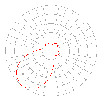 | ||||||||||||||||||
| Azimuth | Ratio | Azimuth | Ratio | Azimuth | Ratio | Azimuth | Ratio | ||||||||||||
| 0 | 0.123 | 10 | 0.135 | 20 | 0.160 | 30 | 0.182 | ||||||||||||
| 40 | 0.193 | 50 | 0.182 | 60 | 0.160 | 70 | 0.135 | ||||||||||||
| 80 | 0.123 | 90 | 0.140 | 100 | 0.171 | 110 | 0.187 | ||||||||||||
| 120 | 0.181 | 130 | 0.157 | 140 | 0.142 | 150 | 0.134 | ||||||||||||
| 160 | 0.190 | 170 | 0.329 | 180 | 0.528 | 190 | 0.718 | ||||||||||||
| 200 | 0.866 | 210 | 0.952 | 220 | 1.000 | 230 | 0.952 | ||||||||||||
| 240 | 0.866 | 250 | 0.718 | 260 | 0.528 | 270 | 0.329 | ||||||||||||
| 280 | 0.190 | 290 | 0.134 | 300 | 0.142 | 310 | 0.157 | ||||||||||||
| 320 | 0.181 | 330 | 0.187 | 340 | 0.171 | 350 | 0.140 | ||||||||||||
Structure Registration Number 1042247 Structure Type: TOWER Registered To: CSC TKR, LLC Structure Address: 2000' Sw Of Sand Pond Road Hamburg Mountain, NJ County Name: Sussex County ASR Issued: 08/13/2020 Date Built: 10/20/1990 Site Elevation: 398 m (1306 ft.) Structure Height: 51 m (167 ft.) Height Overall: 67 m (220 ft.) Overall Height AMSL: 465 m (1526 ft.) FAA Determination: 08/08/1990 FAA Study #: 90-AEA-1118-OE FAA Circular #: 70/7460-1G Paint & Light FAA Chapters: 3, 4, 5, 9 41-08-34.0 N 74-32-23.0 W (NAD 83) 41-08-33.7 N 74-32-24.4 W (Converted to NAD 27) |
15 Neversink Drive Port Jervis, NY 12771 Phone: 845-856-6000 Corporation | Title: President Date: 07/18/2022 Application Certifier DIGITAL RADIO BROADCASTING, INC. Digital Radio Broadcasting, Inc. 15 Neversink Drive Port Jervis, NY 12771 Applicant David O'Neil Rini O'neil, Pc 1200 New Hampshire Avenue, Nw Suite 800 Washington, DC 20036 Charles Williamson Digital Radio Broadcasting, Inc. 15 Neversink Drive Port Jervis, NY 12771 PRESIDENT | |||||||||||||||||