
FCCInfo.com
A Service of Cavell, Mertz & Associates, Inc.
(855) FCC-INFO
|
|
|
|
|
||||||||||||||||
|
|
WWMH Channel: 205A 88.9 MHz Bernardsville, New Jersey Service: FM - A full-service FM station or application. Facility ID: 767773 Fac. Service: FM Status: Construction Permit Application Accepted: 05/19/2023 Application Granted: 08/11/2023 File Number: -0000214972 WWMH CP Expires: 03/13/2026 Application Type: Minor Modification FCC Website Links: LMS Facility Details This Application Other WWMH Applications Other WWMH Applications in CDBS Including Superseded Applications Mailing Address Correspondence for WWMH Correspondence related to application -0000214972 Service Contour - Open Street Map or USGS Map (60 dBu) Service Contour - KML / Google Earth (60 dBu) Public Inspection Files Facility Type: NON-COMMERCIAL EDUC. FM Class: A, A Zone I; I-A; or II station; with 0.1kW-6kW ERP and a class contour distance <=28km Site Location: 40-41-30.6 N 74-30-55.9 W (NAD 83) Site Location: 40-41-30.2 N 74-30-57.3 W (Converted to NAD 27) Effective Radiated Power: 0.001 kW Horiz. ; 4 kW Vert. Antenna Center HAAT: 16 m (52 ft.) Antenna Center AMSL: 111 m (364 ft.) Antenna Center HAG: 41 m (135 ft.) Site Elevation: 69.8 m. (229 ft.) Height Overall*: 60.7 m (199 ft.) (* As Filed In This Application, may differ from ASR Data, Below.) Directional Antenna Antenna Make/Model: None Antenna ID: 1006063 Polarization: | ||||||||||||||||||
| Antenna Data for Antenna Id: 1006063 WWMH FM File: -0000214972 None - Service: FM | 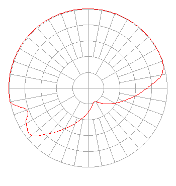 | ||||||||||||||||||
| Azimuth | Ratio | Azimuth | Ratio | Azimuth | Ratio | Azimuth | Ratio | ||||||||||||
| 0 | 1.000 | 10 | 1.000 | 20 | 1.000 | 30 | 1.000 | ||||||||||||
| 40 | 1.000 | 50 | 1.000 | 60 | 1.000 | 70 | 1.000 | ||||||||||||
| 80 | 0.940 | 90 | 0.750 | 100 | 0.600 | 110 | 0.480 | ||||||||||||
| 120 | 0.385 | 130 | 0.310 | 140 | 0.250 | 150 | 0.200 | ||||||||||||
| 160 | 0.200 | 170 | 0.250 | 180 | 0.310 | 190 | 0.385 | ||||||||||||
| 200 | 0.480 | 210 | 0.600 | 220 | 0.750 | 230 | 0.930 | ||||||||||||
| 240 | 0.900 | 250 | 0.820 | 260 | 1.000 | 270 | 1.000 | ||||||||||||
| 280 | 1.000 | 290 | 1.000 | 300 | 1.000 | 310 | 1.000 | ||||||||||||
| 320 | 1.000 | 330 | 1.000 | 340 | 1.000 | 350 | 1.000 | ||||||||||||
Structure Registration Number 1228821 Structure Type: LTOWER Registered To: American Towers LLC Structure Address: 446 Carlton Road Millington, NJ County Name: Morris County ASR Issued: 01/05/2021 Date Built: 04/01/2001 Site Elevation: 69.8 m (229 ft.) Structure Height: 59.4 m (195 ft.) Height Overall: 60.7 m (199 ft.) Overall Height AMSL: 130.5 m (428 ft.) FAA Determination: 03/25/2002 FAA Study #: 02-AEA-0563-OE Paint & Light FAA Chapters: NONE 40-41-30.6 N 74-30-55.9 W (NAD 83) 40-41-30.2 N 74-30-57.3 W (Converted to NAD 27) |
158 W. Clinton Street Dover, NJ 07801 Phone: 973-659-3380 Not-for-Profit | Title: Pastor/president Date: 05/19/2023 Application Certifier Calvary Chapel Morris Hills 158 W. Clinton Street Dover, NJ 07801 Applicant Charles M. Anderson Anderson Associates 5900 Lake Cyrus Drive Hoover, AL 35244 Broadcast Engineering Consultant | |||||||||||||||||