
FCCInfo.com
A Service of Cavell, Mertz & Associates, Inc.
(855) FCC-INFO
|
|
WKRK-FM from 05/31/2007 WKRK-FM from 01/01/2006 WKRK-FM from 06/07/2001 WKRK-FM from 02/25/1994 WKRK-FM from 01/22/1990 WKRK-FM from 09/10/1986 |
|
|
|||||||||||||||||||
|
|
WKRK-FM Channel: 222B 92.3 MHz Cleveland Heights, Ohio Service: FM - A full-service FM station or application. Facility ID: 74473 Fac. Service: FM Analog & Digital Status: License Application Accepted: 11/28/1989 Application Granted: 09/19/1990 File Number: BLH-19891128KA License Expires: 10/01/1996 Prefix Type: This is a license for a commercial FM station Application Type: License To Cover FCC Website Links: LMS Facility Details This Application CDBS Application Other WKRK-FM Applications Other WKRK-FM Applications in CDBS Including Superseded Applications Mailing Address Correspondence for WKRK-FM Correspondence related to application BLH-19891128KA Service Contour - Open Street Map or USGS Map (54 dBu) Service Contour - KML / Google Earth (54 dBu) Public Inspection Files History Cards for WKRK-FM Facility Type: FM STATION Class: B, A Zone I or I-A station; with 25kW-50kW ERP and a class contour distance 39km-52km Site Location: 41-26-32.2 N 81-29-27.4 W (NAD 83) Site Location: 41-26-32.0 N 81-29-28.0 W (Converted to NAD 27) Effective Radiated Power: 40 kW Horiz. ; 36 kW Vert. Antenna Center HAAT: 167 m (548 ft.) Antenna Center AMSL: 465 m (1526 ft.) Antenna Center HAG: 119 m (390 ft.) Calculated Site Elevation: 346 m. (1135 ft.) Height Overall*: 154.2 m (506 ft.) (* As Filed In This Application, may differ from ASR Data, Below.) Directional Antenna Antenna Make/Model: Oddball; usually designed by Applicant ODD890817IC Antenna ID: 13986 Polarization: | |||||||||||||||||||||
| Antenna Data for Antenna Id: 13986 WKRK-FM FM File: BLH-19891128KA Oddball; usually designed by Applicant - ODD890817IC Service: FM | 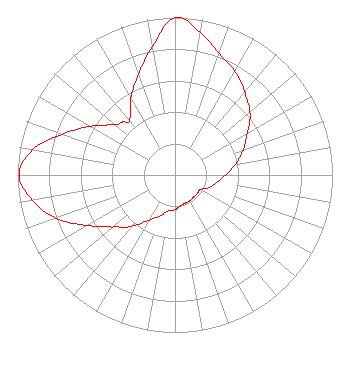 | |||||||||||||||||||||
| Azimuth | Ratio | Azimuth | Ratio | Azimuth | Ratio | Azimuth | Ratio | |||||||||||||||
| 0 | 1.000 | 10 | 0.920 | 20 | 0.820 | 30 | 0.760 | |||||||||||||||
| 40 | 0.690 | 45 | 0.655 | 50 | 0.620 | 60 | 0.530 | |||||||||||||||
| 70 | 0.460 | 80 | 0.390 | 90 | 0.320 | 100 | 0.270 | |||||||||||||||
| 110 | 0.230 | 120 | 0.184 | 130 | 0.184 | 135 | 0.184 | |||||||||||||||
| 140 | 0.184 | 150 | 0.190 | 160 | 0.190 | 170 | 0.200 | |||||||||||||||
| 180 | 0.220 | 190 | 0.230 | 200 | 0.275 | 210 | 0.330 | |||||||||||||||
| 220 | 0.420 | 225 | 0.470 | 230 | 0.515 | 240 | 0.640 | |||||||||||||||
| 250 | 0.805 | 260 | 0.920 | 270 | 0.990 | 280 | 0.920 | |||||||||||||||
| 290 | 0.760 | 300 | 0.620 | 310 | 0.500 | 315 | 0.475 | |||||||||||||||
| 320 | 0.450 | 330 | 0.560 | 340 | 0.680 | 350 | 0.830 | |||||||||||||||
Structure Registration Number 1014708 [ASR Heights Differ from WKRK-FM Application] Structure Type: LTOWER Registered To: American Towers LLC Structure Address: 26501 Renaissance Pky (075037 / Cleveland (wclv)) Cleveland, OH County Name: Cuyahoga County ASR Issued: 10/13/2022 Date Built: 09/25/1990 Site Elevation: 346.9 m (1138 ft.) Structure Height: 137.8 m (452 ft.) Height Overall: 153 m (502 ft.) Overall Height AMSL: 499.9 m (1640 ft.) FAA Determination: 10/06/2022 FAA Study #: 2021-AGL-30697-OE Paint & Light FAA Chapters: A2, H Continue As Is OM&L = 24-HR MED-STROBES 41-26-32.4 N 81-29-28.1 W (NAD 83) 41-26-32.2 N 81-29-28.7 W (Converted to NAD 27) |
2400 Market Street 4th Floor Philadelphia, PA 19103 Phone: 610-660-5610 Limited Liability Company | Date: 11/28/1989 Application Certifier CLEVELAND RADIO LICENSES, L.L.C. 600 Congress Avenue Suite 1400 Austin, TX 78701 Applicant | ||||||||||||||||||||
|
| |||||||||||||||||||||