
FCCInfo.com
A Service of Cavell, Mertz & Associates, Inc.
(855) FCC-INFO
|
|
|
|  |
|
|||||||||||||||
|
|
WDRV Channel: 246B 97.1 MHz Chicago, Illinois Service: FM - A full-service FM station or application. Facility ID: 49552 Fac. Service: FM Analog & Digital Status: License Application Accepted: 09/21/2009 Application Granted: 09/23/2009 File Number: BLH-20090921ABG License Expires: 00/00/0000 Prefix Type: This is a license for a commercial FM station Application Type: License To Cover FCC Website Links: LMS Facility Details This Application CDBS Application Other WDRV Applications Other WDRV Applications in CDBS Including Superseded Applications Mailing Address Correspondence for WDRV Correspondence related to application BLH-20090921ABG Service Contour - Open Street Map or USGS Map (54 dBu) Service Contour - KML / Google Earth (54 dBu) Public Inspection Files History Cards for WDRV Facility Type: FM STATION Class: B, A Zone I or I-A station; with 25kW-50kW ERP and a class contour distance 39km-52km Site Location: 41-53-06.1 N 87-37-18.2 W (NAD 83) Site Location: 41-53-06.0 N 87-37-18.0 W (Converted to NAD 27) Effective Radiated Power: 8.3 kW Transmitter Output Power: 6.602 kW Antenna Center HAAT: 363 m (1191 ft.) Antenna Center AMSL: 542 m (1778 ft.) Antenna Center HAG: 362 m (1188 ft.) Calculated Site Elevation: 180 m. (591 ft.) Height Overall*: 370 m (1214 ft.) (* As Filed In This Application, may differ from ASR Data, Below.) Directional Antenna Antenna Make/Model: Electronics Research Inc. 1083-3CP Antenna ID: 88611 Polarization: | ||||||||||||||||||
| Antenna Data for Antenna Id: 88611 WDRV FM File: BLH-20090921ABG Electronics Research Inc. - 1083-3CP Service: FM | 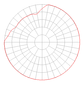 | ||||||||||||||||||
| Azimuth | Ratio | Azimuth | Ratio | Azimuth | Ratio | Azimuth | Ratio | ||||||||||||
| 0 | 0.880 | 10 | 1.000 | 20 | 1.000 | 30 | 1.000 | ||||||||||||
| 40 | 1.000 | 50 | 1.000 | 60 | 1.000 | 70 | 1.000 | ||||||||||||
| 80 | 1.000 | 90 | 1.000 | 100 | 1.000 | 110 | 1.000 | ||||||||||||
| 120 | 1.000 | 130 | 1.000 | 140 | 1.000 | 150 | 1.000 | ||||||||||||
| 160 | 1.000 | 170 | 1.000 | 180 | 1.000 | 190 | 1.000 | ||||||||||||
| 200 | 1.000 | 210 | 1.000 | 220 | 1.000 | 230 | 1.000 | ||||||||||||
| 240 | 1.000 | 250 | 1.000 | 260 | 1.000 | 270 | 1.000 | ||||||||||||
| 280 | 0.915 | 290 | 0.870 | 300 | 0.800 | 310 | 0.800 | ||||||||||||
| 320 | 0.800 | 330 | 0.785 | 340 | 0.780 | 350 | 0.760 | ||||||||||||
Structure Registration Number 1232992 Structure Type: BMAST Registered To: Hubbard Radio Chicago, LLC Structure Address: Amoco Building Chicago, IL County Name: Cook County ASR Issued: 02/24/2023 Date Built: 09/23/2009 Site Elevation: 180.4 m (592 ft.) Structure Height: 370 m (1214 ft.) Height Overall: 370 m (1214 ft.) Overall Height AMSL: 550.4 m (1806 ft.) FAA Determination: 03/06/2002 FAA Study #: 02-AGL-1161-OE Paint & Light FAA Chapters: 1, 3, 8, 17, 21 OM&L TO REMAIN PAINT RED LIGHTS AS PER PRIOR STUDY 01-AGL-8745-OE 41-53-06.1 N 87-37-17.7 W (NAD 83) 41-53-06.0 N 87-37-17.5 W (Converted to NAD 27) |
3415 University Avenue, West St. Paul, MN 55114 Phone: 651-642-4336 Limited Liability Company | Date: 09/21/2009 Application Certifier BONNEVILLE HOLDING COMPANY 55 North 300 West 8th Floor Salt Lake City, UT 84101-3580 Applicant J. TALMAGE BALL 55 North 300 West Salt Lake City, UT 84101 VP ENGINEERING BONNEVILLE INTERNATIONAL KENNETH E. SATTEN Wilkinson Barker Knauer, Llp | |||||||||||||||||