
FCCInfo.com
A Service of Cavell, Mertz & Associates, Inc.
(855) FCC-INFO
|
|
|
|
|
||||||||||||||||
|
|
KMEL-FM2 Channel: 291D 106.1 MHz Walnut Creek, California Service: FB - A booster station or application for a booster. Facility ID: 136936 Fac. Service: FB Analog & Digital Programming Delivery Method: Unspecified Status: License Application Accepted: 04/08/2003 Application Granted: 05/29/2003 File Number: BLFTB-20030408AAS License Expires: 00/00/0000 Prefix Type: This is a license for a booster Application Type: Amendment FCC Website Links: LMS Facility Details This Application CDBS Application Other KMEL-FM2 Applications Other KMEL-FM2 Applications in CDBS Including Superseded Applications Mailing Address Correspondence for KMEL-FM2 Correspondence related to application BLFTB-20030408AAS Service Contour - Open Street Map or USGS Map (60 dBu) Service Contour - KML / Google Earth (60 dBu) Facility Type: FM STATION Class: D, A Noncommercial educational operating with no more than 10W Site Location: 38-01-47.7 N 122-00-07.9 W (NAD 83) Site Location: 38-01-48.0 N 122-00-04.0 W (Converted to NAD 27) Effective Radiated Power: 0 kW Horiz. ; 6.5 kW Vert. Transmitter Output Power: 0.89 kW Antenna Center HAAT: 0 m Antenna Center AMSL: 230 m (755 ft.) Antenna Center HAG: 46 m (151 ft.) Site Elevation: 184 m. (604 ft.) Height Overall*: 57 m (187 ft.) (* As Filed In This Application, may differ from ASR Data, Below.) Directional Antenna Antenna Make/Model: None Antenna ID: 44087 Polarization:
| ||||||||||||||||||
| Antenna Data for Antenna Id: 44087 KMEL-FM2 FB File: BLFTB-20030408AAS None - Service: FB | 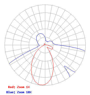 | ||||||||||||||||||
| Azimuth | Ratio | Azimuth | Ratio | Azimuth | Ratio | Azimuth | Ratio | ||||||||||||
| 0 | 0.019 | 10 | 0.011 | 20 | 0.010 | 30 | 0.010 | ||||||||||||
| 40 | 0.010 | 50 | 0.015 | 60 | 0.018 | 70 | 0.020 | ||||||||||||
| 80 | 0.021 | 90 | 0.034 | 100 | 0.114 | 110 | 0.201 | ||||||||||||
| 120 | 0.203 | 130 | 0.118 | 140 | 0.084 | 150 | 0.320 | ||||||||||||
| 160 | 0.603 | 170 | 0.841 | 180 | 0.977 | 190 | 0.980 | ||||||||||||
| 200 | 0.865 | 210 | 0.679 | 220 | 0.475 | 230 | 0.295 | ||||||||||||
| 240 | 0.132 | 250 | 0.035 | 260 | 0.016 | 270 | 0.015 | ||||||||||||
| 280 | 0.017 | 290 | 0.020 | 300 | 0.024 | 310 | 0.028 | ||||||||||||
| 320 | 0.030 | 330 | 0.031 | 340 | 0.030 | 350 | 0.026 | ||||||||||||
Structure Registration Number 1051047 [ASR Heights Differ from KMEL-FM2 Application] Structure Type: LTOWER Registered To: Global Tower, LLC. through American Towers, LLC Structure Address: 4319 Evora Rd (tv Hill #8519) Concord, CA County Name: Contra Costa County ASR Issued: 04/18/2017 Date Built: 10/09/1997 Site Elevation: 184.1 m (604 ft.) Structure Height: 52.1 m (171 ft.) Height Overall: 53.3 m (175 ft.) Overall Height AMSL: 237.4 m (779 ft.) FAA Determination: 04/13/2017 FAA Study #: 2017-AWP-2443-OE Paint & Light FAA Chapters: NONE PRIOR STUDY 2006-AWP-6750-OE 38-01-48.5 N 122-00-08.0 W (NAD 83) 38-01-48.8 N 122-00-04.1 W (Converted to NAD 27) |
7136 S. Yale Avenue Suite 501 Tulsa, OK 74136 Phone: 918-664-4581 | Date: 04/08/2003 Application Certifier AMFM RADIO LICENSES, L.L.C. 2625 S. Memorial Drive Suite A Tulsa, OK 74129 Applicant TROY G. LANGHAM 2625 S. Memorial Dr. Suite: A Tulsa, OK 74129 FCC ENGINEERING SPECIALIST MARISSA G. REPP Hogan & Hartson L.l.p. 555 - 13th Street, N.w. Washington, DC 20004-1109 | |||||||||||||||||