
FCCInfo.com
A Service of Cavell, Mertz & Associates, Inc.
(855) FCC-INFO
|
|
WKGS from 03/01/1998 WKGS from 03/05/1992 WKGS from 05/18/1990 WKGS from 04/19/1990 |
|
|
||||||||||||||||
|
|
WKGS Channel: 294A 106.7 MHz Irondequoit, New York Service: FM - A full-service FM station or application. Facility ID: 3205 Fac. Service: FM Analog & Digital Status: License 73.215 Station Application Accepted: 09/06/2012 Application Granted: 09/10/2012 File Number: BLH-20120906AAY License Expires: 00/00/0000 Prefix Type: This is a license for a commercial FM station Application Type: License To Cover FCC Website Links: LMS Facility Details This Application CDBS Application Other WKGS Applications Other WKGS Applications in CDBS Including Superseded Applications Mailing Address Correspondence for WKGS Correspondence related to application BLH-20120906AAY Service Contour - Open Street Map or USGS Map (60 dBu) Service Contour - KML / Google Earth (60 dBu) Public Inspection Files Facility Type: FM STATION Class: A, A Zone I; I-A; or II station; with 0.1kW-6kW ERP and a class contour distance <=28km Site Location: 43-08-05.2 N 77-35-06.0 W (NAD 83) Site Location: 43-08-05.0 N 77-35-07.0 W (Converted to NAD 27) Effective Radiated Power: 4.6 kW Horiz. ; 4.51 kW Vert. Transmitter Output Power: 4.53 kW Antenna Center HAAT: 114 m (374 ft.) Antenna Center AMSL: 260 m (853 ft.) Antenna Center HAG: 44 m (144 ft.) Calculated Site Elevation: 216 m. (709 ft.) Height Overall*: 98 m (322 ft.) (* As Filed In This Application, may differ from ASR Data, Below.) Directional Antenna Antenna Make/Model: None Shively 6016-1/4-DA panel antenna, 1 section Antenna ID: 98719 Polarization: | ||||||||||||||||||
| Antenna Data for Antenna Id: 98719 WKGS FM File: BLH-20120906AAY None - Shively 6016-1/4-DA panel antenna, 1 section Service: FM | 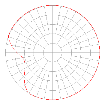 | ||||||||||||||||||
| Azimuth | Ratio | Azimuth | Ratio | Azimuth | Ratio | Azimuth | Ratio | ||||||||||||
| 0 | 1.000 | 10 | 1.000 | 20 | 1.000 | 30 | 1.000 | ||||||||||||
| 40 | 1.000 | 50 | 1.000 | 60 | 1.000 | 70 | 1.000 | ||||||||||||
| 80 | 1.000 | 90 | 1.000 | 100 | 1.000 | 110 | 1.000 | ||||||||||||
| 120 | 1.000 | 130 | 1.000 | 140 | 1.000 | 150 | 1.000 | ||||||||||||
| 160 | 1.000 | 170 | 1.000 | 180 | 1.000 | 190 | 1.000 | ||||||||||||
| 200 | 1.000 | 210 | 1.000 | 220 | 0.905 | 230 | 0.780 | ||||||||||||
| 240 | 0.669 | 250 | 0.624 | 260 | 0.641 | 270 | 0.755 | ||||||||||||
| 280 | 0.882 | 290 | 0.989 | 300 | 1.000 | 310 | 1.000 | ||||||||||||
| 320 | 1.000 | 330 | 1.000 | 340 | 1.000 | 350 | 1.000 | ||||||||||||
Structure Registration Number 1228608 [ASR Heights Differ from WKGS Application] Structure Type: LTOWER Registered To: American Towers LLC Structure Address: 1 Pinnacle Hill Road (221268) Rochester, NY County Name: Monroe County ASR Issued: 08/26/2021 Date Built: 06/09/2008 Site Elevation: 216.4 m (710 ft.) Structure Height: 82.3 m (270 ft.) Height Overall: 97.5 m (320 ft.) Overall Height AMSL: 313.9 m (1030 ft.) FAA Determination: 08/19/2021 FAA Study #: 2021-AEA-8972-OE FAA Circular #: 70/7460-1M Paint & Light FAA Chapters: 4, 8, 15 43-08-05.5 N 77-35-05.7 W (NAD 83) 43-08-05.3 N 77-35-06.7 W (Converted to NAD 27) |
7136 S. Yale Avenue Suite 501 Tulsa, OK 74136 Phone: 918-664-4581 | Date: 09/06/2012 Application Certifier CITICASTERS LICENSES, INC. 7136 S. Yale Avenue Suite 501 Tulsa, OK 74136-2623 Applicant MIKE GUIDOTTI 2625 S. Memorial Dr Tulsa, OK 74129 SENIOR VP ENGINEERING - NORTHEAST TROY G. LANGHAM Clear Channel | |||||||||||||||||
|
| ||||||||||||||||||