
FCCInfo.com
A Service of Cavell, Mertz & Associates, Inc.
(855) FCC-INFO
|
|
K269DB from 07/03/1979 |
|
|
||||||||||||||||
|
|
K269DB Channel: 269D 101.7 MHz Carson City, Nevada Service: FX - A translator or application for a translator. Facility ID: 2093 Fac. Service: FX Programming Delivery Method: Unspecified Status: License Application Accepted: 07/24/2017 Application Granted: 07/31/2017 File Number: BLFT-20170724AAP License Expires: 00/00/0000 Prefix Type: This is a license for a translator Application Type: License To Cover FCC Website Links: LMS Facility Details This Application CDBS Application Other K269DB Applications Other K269DB Applications in CDBS Including Superseded Applications Mailing Address Correspondence for K269DB Correspondence related to application BLFT-20170724AAP Service Contour - Open Street Map or USGS Map (60 dBu) Service Contour - KML / Google Earth (60 dBu) Class: D, A Noncommercial educational operating with no more than 10W Site Location: 39-15-25.7 N 119-42-39.7 W (NAD 83) Site Location: 39-15-26.0 N 119-42-36.0 W (Converted to NAD 27) Effective Radiated Power: 0.25 kW Transmitter Output Power: 0.159 kW Antenna Center HAAT: 0 m Antenna Center AMSL: 2273 m (7457 ft.) Antenna Center HAG: 11 m (36 ft.) Site Elevation: 2262 m. (7421 ft.) Height Overall*: 59 m (194 ft.) (* As Filed In This Application, may differ from ASR Data, Below.) Directional Antenna Antenna Make/Model: None Antenna ID: 127484 Polarization:
| ||||||||||||||||||
| Antenna Data for Antenna Id: 127484 K269DB FX File: BLFT-20170724AAP None - Service: FX Pattern and Field Values Include a 185° Clockwise Rotation | 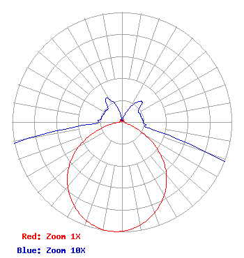 | ||||||||||||||||||
| Azimuth | Ratio | Azimuth | Ratio | Azimuth | Ratio | Azimuth | Ratio | ||||||||||||
| 5 | 0.001 | 15 | 0.003 | 25 | 0.011 | 35 | 0.021 | ||||||||||||
| 45 | 0.026 | 55 | 0.018 | 65 | 0.018 | 75 | 0.018 | ||||||||||||
| 85 | 0.019 | 95 | 0.021 | 105 | 0.036 | 115 | 0.162 | ||||||||||||
| 125 | 0.359 | 135 | 0.548 | 145 | 0.703 | 155 | 0.825 | ||||||||||||
| 165 | 0.919 | 175 | 0.979 | 185 | 1.000 | 195 | 0.979 | ||||||||||||
| 205 | 0.919 | 215 | 0.825 | 225 | 0.703 | 235 | 0.548 | ||||||||||||
| 245 | 0.359 | 255 | 0.162 | 265 | 0.036 | 275 | 0.021 | ||||||||||||
| 285 | 0.019 | 295 | 0.018 | 305 | 0.018 | 315 | 0.018 | ||||||||||||
| 325 | 0.026 | 335 | 0.021 | 345 | 0.011 | 355 | 0.003 | ||||||||||||
Structure Registration Number 1011093 Structure Type: TOWER Registered To: Americom Limited Partnership Structure Address: Mc Clellan Peak Carson City, NV County Name: Storey County ASR Issued: 03/10/2022 Date Built: 02/01/1983 Site Elevation: 2261.6 m (7420 ft.) Structure Height: 59.1 m (194 ft.) Height Overall: 59.1 m (194 ft.) Overall Height AMSL: 2320.7 m (7614 ft.) FAA Determination: 12/28/2011 FAA Study #: 2011-AWP-8073-OE Paint & Light FAA Chapters: NONE 39-15-25.2 N 119-42-40.0 W (NAD 83) 39-15-25.5 N 119-42-36.3 W (Converted to NAD 27) |
961 Matley Lane, Suite 120 Reno, NV 89502 Phone: 775-829-1964 | Date: 07/24/2017 Application Certifier RENO MEDIA GROUP, L.P. 961 Matley Lane Suite 120 Reno, NV 89502 Applicant ERIK C. SWANSON, P.E. Hatfield & Dawson Consulting Engineers, 9500 Greenwood Ave N Seattle, WA 98103 CONSULTING ENGINEER DENNIS P. CORBETT, ESQ. Telecommunications Law Professionals, Pllc 1025 Connecticut Avenue, Nw Suite 1011 Washington, DC 20036 | |||||||||||||||||