
FCCInfo.com
A Service of Cavell, Mertz & Associates, Inc.
(855) FCC-INFO
|
|
K246CJ from 05/19/2004 |
|
|
||||||||||||||||
|
|
K246CJ Channel: 246D 97.1 MHz Sioux City, Iowa Service: FX - A translator or application for a translator. Facility ID: 147458 Fac. Service: FX Programming Delivery Method: Unspecified Status: License Application Accepted: 04/11/2016 Application Granted: 05/17/2016 File Number: BLFT-20160411AAX License Expires: 00/00/0000 Prefix Type: This is a license for a translator Application Type: License To Cover FCC Website Links: LMS Facility Details This Application CDBS Application Other K246CJ Applications Other K246CJ Applications in CDBS Including Superseded Applications Mailing Address Correspondence for K246CJ Correspondence related to application BLFT-20160411AAX Service Contour - Open Street Map or USGS Map (60 dBu) Service Contour - KML / Google Earth (60 dBu) Class: D, A Noncommercial educational operating with no more than 10W Site Location: 42-32-16.0 N 96-26-59.1 W (NAD 83) Site Location: 42-32-16.0 N 96-26-58.0 W (Converted to NAD 27) Effective Radiated Power: 0.25 kW Transmitter Output Power: 0.814 kW Antenna Center HAAT: 0 m Antenna Center AMSL: 486 m (1594 ft.) Antenna Center HAG: 76 m (249 ft.) Site Elevation: 410 m. (1345 ft.) Height Overall*: 110 m (361 ft.) (* As Filed In This Application, may differ from ASR Data, Below.) Directional Antenna Antenna Make/Model: None Antenna ID: 121255 Polarization:
| ||||||||||||||||||
| Antenna Data for Antenna Id: 121255 K246CJ FX File: BLFT-20160411AAX None - Service: FX Pattern and Field Values Include a 200° Clockwise Rotation | 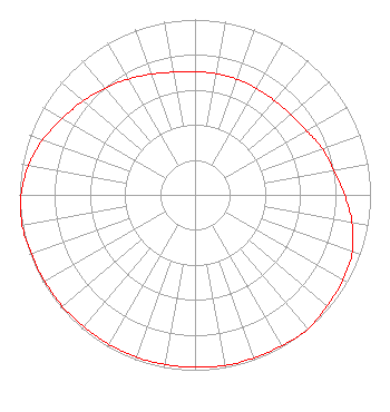 | ||||||||||||||||||
| Azimuth | Ratio | Azimuth | Ratio | Azimuth | Ratio | Azimuth | Ratio | ||||||||||||
| 0 | 0.702 | 10 | 0.702 | 20 | 0.702 | 30 | 0.702 | ||||||||||||
| 40 | 0.702 | 50 | 0.712 | 60 | 0.732 | 70 | 0.772 | ||||||||||||
| 80 | 0.802 | 90 | 0.853 | 100 | 0.909 | 110 | 0.953 | ||||||||||||
| 120 | 0.973 | 130 | 0.983 | 140 | 1.000 | 150 | 0.992 | ||||||||||||
| 160 | 0.988 | 170 | 0.988 | 180 | 0.983 | 190 | 0.983 | ||||||||||||
| 200 | 0.983 | 210 | 0.983 | 220 | 0.983 | 230 | 0.988 | ||||||||||||
| 240 | 0.988 | 250 | 0.992 | 260 | 1.000 | 270 | 0.991 | ||||||||||||
| 280 | 0.963 | 290 | 0.923 | 300 | 0.873 | 310 | 0.832 | ||||||||||||
| 320 | 0.792 | 330 | 0.762 | 340 | 0.732 | 350 | 0.710 | ||||||||||||
Structure Registration Number 1025581 Structure Type: TOWER Registered To: ELECTRONIC ENGINEERING CO Structure Address: 4201 Talbot Rd Sioux City, IA County Name: Woodbury County ASR Issued: 07/30/1997 Date Built: 12/24/1997 Site Elevation: 410 m (1345 ft.) Structure Height: 107 m (351 ft.) Height Overall: 109.7 m (360 ft.) Overall Height AMSL: 519.7 m (1705 ft.) FAA Determination: 06/20/1997 FAA Study #: 97-ACE-0191-OE FAA Circular #: 70/7460-1J Paint & Light FAA Chapters: 4, 8, 13 Removed expiration and final dates from determination. Scenario 2./jjs/case#635066 42-32-16.0 N 96-26-59.0 W (NAD 83) 42-32-16.0 N 96-26-57.9 W (Converted to NAD 27) |
103 Virginia Street Suite 203 Sioux City, IA 51101 Phone: 712-255-9710 | Date: 04/11/2016 Application Certifier CUP OF DIRT 700 4th Street Suite 210 Sioux City, IA 51101 Applicant JOHN SMALL 700 4th Street Suite 210 Sioux City, IA 51101 OWNER SCOTT CINNAMON Law Offices Of Scott C Cinnamon 1250 Connecticut Ave # 200-144 Washington, DC 20036 | |||||||||||||||||