
FCCInfo.com
A Service of Cavell, Mertz & Associates, Inc.
(855) FCC-INFO
|
|
|
|
|
||||||||||||||||
|
|
WBLI Channel: 291B 106.1 MHz Patchogue, New York Service: FM - A full-service FM station or application. Facility ID: 37235 Fac. Service: FM Analog & Digital Status: License Application Accepted: 04/29/2010 Application Granted: 05/31/2011 File Number: BLH-20100429ADY License Expires: 00/00/0000 Prefix Type: This is a license for a commercial FM station Application Type: License To Cover FCC Website Links: LMS Facility Details This Application CDBS Application Other WBLI Applications Other WBLI Applications in CDBS Including Superseded Applications Mailing Address Correspondence for WBLI Correspondence related to application BLH-20100429ADY Service Contour - Open Street Map or USGS Map (54 dBu) Service Contour - KML / Google Earth (54 dBu) Public Inspection Files History Cards for WBLI Facility Type: FM STATION Class: B, A Zone I or I-A station; with 25kW-50kW ERP and a class contour distance 39km-52km Site Location: 40-50-32.4 N 73-02-23.4 W (NAD 83) Site Location: 40-50-32.0 N 73-02-25.0 W (Converted to NAD 27) Effective Radiated Power: 49 kW Transmitter Output Power: 18.4 kW Antenna Center HAAT: 152 m (499 ft.) Antenna Center AMSL: 175 m (574 ft.) Antenna Center HAG: 96 m (315 ft.) Calculated Site Elevation: 79 m. (259 ft.) Height Overall*: 107 m (351 ft.) (* As Filed In This Application, may differ from ASR Data, Below.) Directional Antenna Antenna Make/Model: Electronics Research Inc. MP-4AC-DA-HW, 4 sections,0.5 wavelength spacing Antenna ID: 88811 Polarization:
| ||||||||||||||||||
| Antenna Data for Antenna Id: 88811 WBLI FM File: BLH-20100429ADY Electronics Research Inc. - MP-4AC-DA-HW, 4 sections,0.5 wavelength spacing Service: FM | 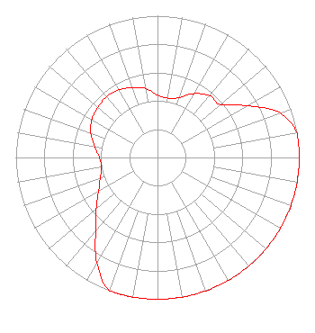 | ||||||||||||||||||
| Azimuth | Ratio | Azimuth | Ratio | Azimuth | Ratio | Azimuth | Ratio | ||||||||||||
| 0 | 0.440 | 10 | 0.425 | 20 | 0.450 | 30 | 0.520 | ||||||||||||
| 40 | 0.570 | 50 | 0.580 | 60 | 0.730 | 70 | 0.920 | ||||||||||||
| 80 | 1.000 | 90 | 1.000 | 100 | 1.000 | 110 | 1.000 | ||||||||||||
| 120 | 1.000 | 130 | 1.000 | 140 | 1.000 | 150 | 1.000 | ||||||||||||
| 160 | 1.000 | 170 | 1.000 | 180 | 1.000 | 190 | 1.000 | ||||||||||||
| 200 | 1.000 | 210 | 0.855 | 220 | 0.680 | 230 | 0.565 | ||||||||||||
| 240 | 0.480 | 250 | 0.430 | 260 | 0.400 | 270 | 0.410 | ||||||||||||
| 280 | 0.450 | 290 | 0.500 | 300 | 0.535 | 310 | 0.550 | ||||||||||||
| 320 | 0.560 | 330 | 0.550 | 340 | 0.525 | 350 | 0.495 | ||||||||||||
Structure Registration Number 1003317 Structure Type: LTOWER Registered To: High-Tower Communications, Inc. Structure Address: 95 Lidge Dr., S Of Willow Farmingville, NY County Name: Suffolk County ASR Issued: 02/18/2022 Date Built: 04/01/1993 Site Elevation: 79.2 m (260 ft.) Structure Height: 106.7 m (350 ft.) Height Overall: 106.7 m (350 ft.) Overall Height AMSL: 185.9 m (610 ft.) FAA Determination: 03/18/1994 FAA Study #: 94-AEA-0328-OE FAA Circular #: 70/7460-1H Paint & Light FAA Chapters: 3, 4, 5, 13 40-50-32.0 N 73-02-23.0 W (NAD 83) 40-50-31.6 N 73-02-24.6 W (Converted to NAD 27) |
1601 W Peachtree Street Ne Atlanta, GA 30309 Phone: 404-897-7000 Limited Liability Company | Date: 04/29/2010 Application Certifier COX RADIO, INC. 555 Sunrise Highway West Babylon, NY 11704 Applicant CHARLES A. COOPER Du Treil, Lundin & Rackley, Inc. 201 Fletcher Avenue Sarasto, FL 34237 TECHNICAL CONSULTANT ROBERT J. FOLLIARD, III, ESQ. Dow Lohnes Pllc | |||||||||||||||||
| |||||||||||||||||||