
FCCInfo.com
A Service of Cavell, Mertz & Associates, Inc.
(855) FCC-INFO
|
|
|
|  |
|
|||||||||||||||
|
|
WFRS Channel: 205A 88.9 MHz Smithtown, New York Service: FM - A full-service FM station or application. Facility ID: 20927 Fac. Service: FM Status: License Application Accepted: 05/30/2013 Application Granted: 06/27/2013 File Number: BMLED-20130530AMD License Expires: 00/00/0000 Prefix Type: This is a modification of license for a noncommercial educational FM station Application Type: Minor Modification FCC Website Links: LMS Facility Details This Application CDBS Application Other WFRS Applications Other WFRS Applications in CDBS Including Superseded Applications Mailing Address Correspondence for WFRS Correspondence related to application BMLED-20130530AMD Service Contour - Open Street Map or USGS Map (60 dBu) Service Contour - KML / Google Earth (60 dBu) Public Inspection Files Facility Type: NON-COMMERCIAL EDUC. FM Class: A, A Zone I; I-A; or II station; with 0.1kW-6kW ERP and a class contour distance <=28km Site Location: 40-48-27.4 N 73-10-46.4 W (NAD 83) Site Location: 40-48-27.0 N 73-10-48.0 W (Converted to NAD 27) Effective Radiated Power: 1.5 kW Horiz. ; 1.45 kW Vert. Transmitter Output Power: 2.8 kW Antenna Center HAAT: 132 m (433 ft.) Antenna Center AMSL: 154 m (505 ft.) Antenna Center HAG: 130 m (427 ft.) Calculated Site Elevation: 24 m. (79 ft.) Height Overall*: 138 m (453 ft.) (* As Filed In This Application, may differ from ASR Data, Below.) Directional Antenna Antenna Make/Model: DIELECTRIC DCR-G1 Antenna ID: 13846 Polarization:
| ||||||||||||||||||
| Antenna Data for Antenna Id: 13846 WFRS FM File: BMLED-20130530AMD DIELECTRIC - DCR-G1 Service: FM | 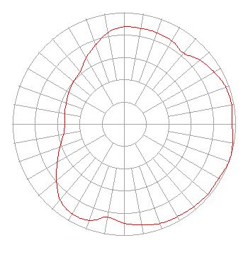 | ||||||||||||||||||
| Azimuth | Ratio | Azimuth | Ratio | Azimuth | Ratio | Azimuth | Ratio | ||||||||||||
| 0 | 0.870 | 10 | 0.870 | 20 | 0.870 | 30 | 0.860 | ||||||||||||
| 40 | 0.830 | 50 | 0.890 | 60 | 0.930 | 70 | 0.970 | ||||||||||||
| 80 | 0.980 | 90 | 0.970 | 100 | 0.990 | 110 | 1.000 | ||||||||||||
| 120 | 0.980 | 130 | 0.980 | 140 | 0.970 | 150 | 0.960 | ||||||||||||
| 160 | 0.950 | 170 | 0.920 | 180 | 0.890 | 190 | 0.850 | ||||||||||||
| 200 | 0.920 | 210 | 0.930 | 220 | 0.890 | 230 | 0.790 | ||||||||||||
| 240 | 0.690 | 250 | 0.610 | 260 | 0.550 | 270 | 0.530 | ||||||||||||
| 280 | 0.540 | 290 | 0.550 | 300 | 0.570 | 310 | 0.590 | ||||||||||||
| 320 | 0.610 | 330 | 0.680 | 340 | 0.750 | 350 | 0.830 | ||||||||||||
Structure Registration Number 1007665 [ASR Heights Differ from WFRS Application] Structure Type: LTOWER Registered To: Islandia Studios LLC Structure Address: 3200 Express Dr S Central Islip, NY County Name: Suffolk County ASR Issued: 03/02/2023 Date Built: 02/03/2014 Site Elevation: 26.9 m (88 ft.) Structure Height: 126.2 m (414 ft.) Height Overall: 126.2 m (414 ft.) Overall Height AMSL: 153.1 m (502 ft.) FAA Determination: 04/27/2001 FAA Study #: 01-AEA-0990-OE FAA Circular #: 70/7460-1K Paint & Light FAA Chapters: 3, 4, 5, 12 40-48-26.0 N 73-10-46.0 W (NAD 83) 40-48-25.6 N 73-10-47.6 W (Converted to NAD 27) |
112 North Elm Street Shenandoah, IA 51601 Phone: 712-246-5151 Not-for-Profit | Date: 05/30/2013 Application Certifier FAMILY STATIONS, INC. Harvest Broadcasting Assn. D/b/a Harvest Translators, Inc. 4135 Northgate Boulevard Suite 1 Sacramento, CA 95834 Applicant LINDA ADAMS 4135 Northgate Boulevard Ste. 1 Sacremento, CA 95834 ENGINEER MICHELLE A. MCCLURE, ESQ. Fletcher, Heald & Hildreth, P.l.c. | |||||||||||||||||