
FCCInfo.com
A Service of Cavell, Mertz & Associates, Inc.
(855) FCC-INFO
|
|
KKLA-FM from 10/18/1985 |
|
|
||||||||||||||||
|
|
KKLA-FM Channel: 258B 99.5 MHz Los Angeles, California Service: FM - A full-service FM station or application. Facility ID: 48453 Fac. Service: FM Status: License 73.215 Station Application Accepted: 03/25/2016 Application Granted: 03/31/2016 File Number: BMLH-20160325AAB License Expires: 00/00/0000 Prefix Type: This is a modification of a license for a commecial FM station Application Type: Minor Modification FCC Website Links: LMS Facility Details This Application CDBS Application Other KKLA-FM Applications Other KKLA-FM Applications in CDBS Including Superseded Applications Mailing Address Correspondence for KKLA-FM Correspondence related to application BMLH-20160325AAB Service Contour - Open Street Map or USGS Map (54 dBu) Service Contour - KML / Google Earth (54 dBu) Public Inspection Files History Cards for KKLA-FM Facility Type: FM STATION Class: B, A Zone I or I-A station; with 25kW-50kW ERP and a class contour distance 39km-52km Site Location: 34-13-26.0 N 118-03-47.2 W (NAD 83) Site Location: 34-13-26.0 N 118-03-44.0 W (Converted to NAD 27) Effective Radiated Power: 10 kW Transmitter Output Power: 6.3 kW Antenna Center HAAT: 902 m (2959 ft.) Antenna Center AMSL: 1801 m (5909 ft.) Antenna Center HAG: 76 m (249 ft.) Calculated Site Elevation: 1725 m. (5659 ft.) Height Overall*: 110.6 m (363 ft.) (* As Filed In This Application, may differ from ASR Data, Below.) Directional Antenna Antenna Make/Model: Electronics Research Inc. 1182-1CP-DA Antenna ID: 71714 Polarization: | ||||||||||||||||||
| Antenna Data for Antenna Id: 71714 KKLA-FM FM File: BMLH-20160325AAB Electronics Research Inc. - 1182-1CP-DA Service: FM | 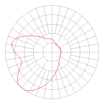 | ||||||||||||||||||
| Azimuth | Ratio | Azimuth | Ratio | Azimuth | Ratio | Azimuth | Ratio | ||||||||||||
| 0 | 0.270 | 10 | 0.240 | 20 | 0.200 | 30 | 0.180 | ||||||||||||
| 40 | 0.180 | 50 | 0.180 | 60 | 0.180 | 70 | 0.190 | ||||||||||||
| 75 | 0.190 | 80 | 0.180 | 90 | 0.180 | 100 | 0.180 | ||||||||||||
| 110 | 0.180 | 120 | 0.200 | 130 | 0.220 | 140 | 0.250 | ||||||||||||
| 150 | 0.290 | 160 | 0.360 | 170 | 0.450 | 180 | 0.560 | ||||||||||||
| 190 | 0.700 | 200 | 0.830 | 210 | 0.950 | 216 | 1.000 | ||||||||||||
| 220 | 1.000 | 226 | 1.000 | 230 | 0.960 | 240 | 0.820 | ||||||||||||
| 250 | 0.690 | 255 | 0.680 | 260 | 0.700 | 270 | 0.800 | ||||||||||||
| 280 | 0.870 | 282 | 0.875 | 290 | 0.830 | 300 | 0.679 | ||||||||||||
| 310 | 0.540 | 320 | 0.430 | 330 | 0.350 | 340 | 0.300 | ||||||||||||
| 350 | 0.290 | ||||||||||||||||||
Structure Registration Number 1012244 Structure Type: TOWER Registered To: KCETLink Structure Address: 47 Audio Rd Mount Wilson, CA County Name: Los Angeles County ASR Issued: 08/26/2014 Date Built: 08/01/1982 Site Elevation: 1724.8 m (5659 ft.) Structure Height: 91.4 m (300 ft.) Height Overall: 110.6 m (363 ft.) Overall Height AMSL: 1835.4 m (6022 ft.) FAA Determination: 03/26/1964 FAA Study #: LAX-OE-58 Paint & Light FAA Chapters: None 34-13-26.0 N 118-03-47.0 W (NAD 83) 34-13-26.0 N 118-03-43.8 W (Converted to NAD 27) |
4880 Santa Rosa Road Camarillo, CA 93012 | Date: 03/25/2016 Application Certifier NEW INSPIRATION BROADCASTING COMPANY, INC. 4880 Santa Rosa Road Camarillo, CA 93012 Applicant WILLIAM J. GETZ Carl T. Jones Corporation 7901 Yarnwood Court Springfield, VA 22153-7901 CONSULTING ENGINEER FRANK R. JAZZO, ESQ. Fletcher, Heald & Hildreth, P.l.c. | |||||||||||||||||
| |||||||||||||||||||