
FCCInfo.com
A Service of Cavell, Mertz & Associates, Inc.
(855) FCC-INFO
|
|
|
|
|
||||||||||||||||
|
|
W256CL Channel: 256D 99.1 MHz Park Forest, Illinois Service: FX - A translator or application for a translator. Facility ID: 152811 Fac. Service: FX Programming Delivery Method: Unspecified Status: License Application Accepted: 08/25/2017 Application Granted: 09/11/2017 File Number: BLFT-20170825ABG License Expires: 00/00/0000 Prefix Type: This is a license for a translator Application Type: License To Cover FCC Website Links: LMS Facility Details This Application CDBS Application Other W256CL Applications Other W256CL Applications in CDBS Including Superseded Applications Mailing Address Correspondence for W256CL Correspondence related to application BLFT-20170825ABG Service Contour - Open Street Map or USGS Map (60 dBu) Service Contour - KML / Google Earth (60 dBu) Class: D, A Noncommercial educational operating with no more than 10W Site Location: 41-37-15.1 N 87-40-55.2 W (NAD 83) Site Location: 41-37-15.0 N 87-40-55.0 W (Converted to NAD 27) Effective Radiated Power: 0 kW Horiz. ; 0.087 kW Vert. Transmitter Output Power: 0.072 kW Antenna Center HAAT: 0 m Antenna Center AMSL: 0 m Horiz.; 309 m Vert. Antenna Center HAG: 0 m Horiz.; 125 m Vert. Site Elevation: 184 m. (604 ft.) Height Overall*: 135 m (443 ft.) (* As Filed In This Application, may differ from ASR Data, Below.) Directional Antenna Antenna Make/Model: None Antenna ID: 127987 Polarization:
| ||||||||||||||||||
| Antenna Data for Antenna Id: 127987 W256CL FX File: BLFT-20170825ABG None - Service: FX Pattern and Field Values Include a 8° Clockwise Rotation | 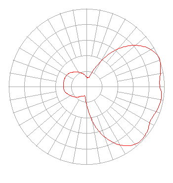 | ||||||||||||||||||
| Azimuth | Ratio | Azimuth | Ratio | Azimuth | Ratio | Azimuth | Ratio | ||||||||||||
| 8 | 0.115 | 18 | 0.148 | 28 | 0.330 | 38 | 0.586 | ||||||||||||
| 48 | 0.789 | 58 | 0.932 | 68 | 1.000 | 78 | 0.969 | ||||||||||||
| 88 | 0.940 | 98 | 0.973 | 108 | 0.956 | 118 | 0.933 | ||||||||||||
| 128 | 0.974 | 138 | 0.979 | 148 | 0.894 | 158 | 0.733 | ||||||||||||
| 168 | 0.512 | 178 | 0.266 | 188 | 0.132 | 198 | 0.128 | ||||||||||||
| 208 | 0.140 | 218 | 0.170 | 228 | 0.200 | 238 | 0.229 | ||||||||||||
| 248 | 0.259 | 258 | 0.288 | 268 | 0.296 | 278 | 0.299 | ||||||||||||
| 288 | 0.299 | 298 | 0.295 | 308 | 0.279 | 318 | 0.250 | ||||||||||||
| 328 | 0.221 | 338 | 0.190 | 348 | 0.161 | 358 | 0.130 | ||||||||||||
Structure Registration Number 1056805 Structure Type: TOWER Registered To: K2 Towers III, LLC Structure Address: 15000 S Rockwell Posen, IL County Name: Cook County ASR Issued: 06/22/2022 Date Built: 10/01/1999 Site Elevation: 184 m (604 ft.) Structure Height: 135 m (443 ft.) Height Overall: 135 m (443 ft.) Overall Height AMSL: 319 m (1047 ft.) FAA Determination: 09/21/1998 FAA Study #: 98-AGL-4567-OE FAA Circular #: 70/7460-1J Paint & Light FAA Chapters: 3, 4, 5, 13 PRIOR FAA 96-AGL-2948-OE 41-37-15.0 N 87-40-55.0 W (NAD 83) 41-37-14.9 N 87-40-54.8 W (Converted to NAD 27) |
428 Heritage Bridge Avenue Henderson, NV 89011 Phone: 714-809-0600 Limited Liability Company | Date: 08/25/2017 Application Certifier EDGEWATER BROADCASTING, INC. 160 W Gooding Street Twin Falls, ID 83301 Applicant GENE WISNIEWSKI 160 Gooding Street West Suite A Twin Falls, ID 83301 CONSULTING ENGINEER CLARK PARRISH Edgewater Broadcasting, Inc. 160 W Gooding Street Twin Falls, ID 83301 | |||||||||||||||||