
FCCInfo.com
A Service of Cavell, Mertz & Associates, Inc.
(855) FCC-INFO
|
|
KEGA-FM6 from 09/26/2003 KEGA-FM6 from 07/30/2003 KEGA-FM6 from 07/03/2003 |
|
|
||||||||||||||||
|
|
KNAH-FM6 Channel: 268D 101.5 MHz Bountiful, Utah Service: FB - A booster station or application for a booster. Facility ID: 137910 Fac. Service: FB Programming Delivery Method: Unspecified Status: License Application Accepted: 11/03/2003 Application Granted: 03/12/2004 File Number: BLFTB-20031103ABN License Expires: 00/00/0000 Prefix Type: This is a license for a booster Application Type: License To Cover FCC Website Links: LMS Facility Details This Application CDBS Application Other KNAH-FM6 Applications Other KNAH-FM6 Applications in CDBS Including Superseded Applications Mailing Address Correspondence for KNAH-FM6 Correspondence related to application BLFTB-20031103ABN Service Contour - Open Street Map or USGS Map (60 dBu) Service Contour - KML / Google Earth (60 dBu) Facility Type: FM STATION Class: D, A Noncommercial educational operating with no more than 10W Site Location: 40-50-04.8 N 111-52-05.8 W (NAD 83) Site Location: 40-50-05.0 N 111-52-03.0 W (Converted to NAD 27) Effective Radiated Power: 1.2 kW Transmitter Output Power: 0.28 kW Antenna Center HAAT: 0 m Antenna Center AMSL: 1828 m (5997 ft.) Antenna Center HAG: 19 m (62 ft.) Site Elevation: 1809 m. (5935 ft.) Height Overall*: 23 m (75 ft.) (* As Filed In This Application, may differ from ASR Data, Below.) Directional Antenna Antenna Make/Model: None JAMPRO JCPD4H/3V-1S Antenna ID: 46151 Polarization:
| ||||||||||||||||||
| Antenna Data for Antenna Id: 46151 KNAH-FM6 FB File: BLFTB-20031103ABN None - JAMPRO JCPD4H/3V-1S Service: FB | 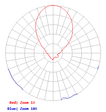 | ||||||||||||||||||
| Azimuth | Ratio | Azimuth | Ratio | Azimuth | Ratio | Azimuth | Ratio | ||||||||||||
| 0 | 1.000 | 10 | 0.970 | 20 | 0.890 | 30 | 0.780 | ||||||||||||
| 40 | 0.640 | 50 | 0.500 | 60 | 0.350 | 70 | 0.220 | ||||||||||||
| 80 | 0.180 | 90 | 0.140 | 100 | 0.110 | 110 | 0.100 | ||||||||||||
| 120 | 0.130 | 130 | 0.140 | 140 | 0.120 | 150 | 0.100 | ||||||||||||
| 160 | 0.100 | 170 | 0.100 | 180 | 0.140 | 190 | 0.130 | ||||||||||||
| 200 | 0.120 | 210 | 0.120 | 220 | 0.100 | 230 | 0.100 | ||||||||||||
| 240 | 0.100 | 250 | 0.100 | 260 | 0.110 | 270 | 0.140 | ||||||||||||
| 280 | 0.150 | 290 | 0.170 | 300 | 0.260 | 310 | 0.380 | ||||||||||||
| 320 | 0.540 | 330 | 0.720 | 340 | 0.860 | 350 | 0.960 | ||||||||||||
Structure Registration Number 1238345 Structure Type: TOWER Registered To: Broadway Media, LLC Structure Address: Black Mountain Bountiful, UT County Name: Davis County ASR Issued: 07/08/2014 Date Built: 11/01/2003 Site Elevation: 1809.3 m (5936 ft.) Structure Height: 22.9 m (75 ft.) Height Overall: 22.9 m (75 ft.) Overall Height AMSL: 1832.2 m (6011 ft.) FAA Determination: 01/14/2003 FAA Study #: 2002-ANM-2322-OE Paint & Light FAA Chapters: NONE 40-50-04.9 N 111-52-05.6 W (NAD 83) 40-50-05.1 N 111-52-02.8 W (Converted to NAD 27) |
595 S. Riverwoods Parkway Suite 400 Logan, UT 84321 Phone: 801-961-1101 Limited Liability Company | Date: 11/03/2003 Application Certifier SIMMONS-SLC, LS, LLC 515 South 700 East Suite 1c Salt Lake City, UT 84102 Applicant SCOT W. MATHEWS 515 S. 700 E Salt Lake City, UT 84102 ENGINEER KEVIN LATEK Dow, Lohnes & Albertson, Pllc 1200 New Hampshire Avenue, Nw Suite 800 Washington, DC 20036 | |||||||||||||||||