
FCCInfo.com
A Service of Cavell, Mertz & Associates, Inc.
(855) FCC-INFO
|
|
|
|
|
||||||||||||||||
|
|
W206AY Channel: 206D 89.1 MHz Fruitland, Maryland Service: FX - A translator or application for a translator. Facility ID: 91849 Fac. Service: FX Programming Delivery Method: Unspecified Status: License Application Accepted: 12/11/2009 Application Granted: 12/22/2009 File Number: BLFT-20091211ADP License Expires: 00/00/0000 Prefix Type: This is a license for a translator Application Type: License To Cover FCC Website Links: LMS Facility Details This Application CDBS Application Other W206AY Applications Other W206AY Applications in CDBS Including Superseded Applications Mailing Address Correspondence for W206AY Correspondence related to application BLFT-20091211ADP Service Contour - Open Street Map or USGS Map (60 dBu) Service Contour - KML / Google Earth (60 dBu) Class: D, A Noncommercial educational operating with no more than 10W Site Location: 38-17-05.4 N 75-39-53.7 W (NAD 83) Site Location: 38-17-05.0 N 75-39-55.0 W (Converted to NAD 27) Effective Radiated Power: 0.013 kW Transmitter Output Power: 0.022 kW Antenna Center HAAT: 128.1 m Horiz.; 0 m Vert. Antenna Center AMSL: 133 m (436 ft.) Antenna Center HAG: 125 m (410 ft.) Site Elevation: 8 m. (26 ft.) Height Overall*: 143 m (469 ft.) (* As Filed In This Application, may differ from ASR Data, Below.) Directional Antenna Antenna Make/Model: None Antenna ID: 16125 Polarization:
| ||||||||||||||||||
| Antenna Data for Antenna Id: 16125 W206AY FX File: BLFT-20091211ADP None - Service: FX Pattern and Field Values Include a 35° Clockwise Rotation | 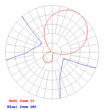 | ||||||||||||||||||
| Azimuth | Ratio | Azimuth | Ratio | Azimuth | Ratio | Azimuth | Ratio | ||||||||||||
| 5 | 0.829 | 15 | 0.920 | 25 | 0.979 | 35 | 1.000 | ||||||||||||
| 45 | 0.979 | 55 | 0.920 | 65 | 0.829 | 75 | 0.715 | ||||||||||||
| 85 | 0.570 | 95 | 0.388 | 105 | 0.187 | 115 | 0.045 | ||||||||||||
| 125 | 0.030 | 135 | 0.032 | 145 | 0.037 | 155 | 0.046 | ||||||||||||
| 165 | 0.065 | 175 | 0.142 | 185 | 0.202 | 195 | 0.234 | ||||||||||||
| 205 | 0.250 | 215 | 0.260 | 225 | 0.250 | 235 | 0.234 | ||||||||||||
| 245 | 0.202 | 255 | 0.142 | 265 | 0.065 | 275 | 0.046 | ||||||||||||
| 285 | 0.037 | 295 | 0.032 | 305 | 0.030 | 315 | 0.045 | ||||||||||||
| 325 | 0.187 | 335 | 0.388 | 345 | 0.570 | 355 | 0.715 | ||||||||||||
Structure Registration Number 1271185 Structure Type: TOWER Registered To: Pinnacle Towers LLC Structure Address: Eden Allen Road Eden, MD County Name: Somerset County ASR Issued: 05/06/2016 Date Built: 10/09/2009 Site Elevation: 7.9 m (26 ft.) Structure Height: 135.9 m (446 ft.) Height Overall: 142.9 m (469 ft.) Overall Height AMSL: 150.8 m (495 ft.) FAA Determination: 08/06/2009 FAA Study #: 2009-AEA-2085-OE FAA Circular #: 70/7460-1K Paint & Light FAA Chapters: 4, 6, 12 PRIOR STUDY 2009-AEA-2086-OE 38-17-05.1 N 75-39-53.5 W (NAD 83) 38-17-04.7 N 75-39-54.8 W (Converted to NAD 27) |
P.o. Box 391 4002 N. 3300 E. Twin Falls, ID 83303 Phone: 208-733-3133 | Date: 12/11/2009 Application Certifier CALVARY CHAPEL OF TWIN FALLS, INC. P.o. Box 391 Twin Falls, ID 83303 Applicant LOIS MILLS Po Box 391 Twin Falls, ID 83303 APPLICATIONS TECHNICIAN CARY S. TEPPER, ESQ. Booth, Freret, Imlay & Tepper, Pc 7900 Wisconsin Avenue Suite 304 Bethesda, MD 20814-3628 | |||||||||||||||||