
FCCInfo.com
A Service of Cavell, Mertz & Associates, Inc.
(855) FCC-INFO
|
|
K203FE from 05/05/1994 |
|
|
||||||||||||||||
|
|
K203FE Channel: 203D 88.5 MHz Tahlequah, Oklahoma Service: FX - A translator or application for a translator. Facility ID: 43694 Fac. Service: FX Programming Delivery Method: Unspecified Status: License Application Accepted: 07/25/2011 Application Granted: 08/11/2011 File Number: BLFT-20110725AGA License Expires: 00/00/0000 Prefix Type: This is a license for a translator Application Type: License To Cover FCC Website Links: LMS Facility Details This Application CDBS Application Other K203FE Applications Other K203FE Applications in CDBS Including Superseded Applications Mailing Address Correspondence for K203FE Correspondence related to application BLFT-20110725AGA Service Contour - Open Street Map or USGS Map (60 dBu) Service Contour - KML / Google Earth (60 dBu) Class: D, A Noncommercial educational operating with no more than 10W Site Location: 35-59-19.0 N 94-56-20.0 W (NAD 83) Site Location: 35-59-18.7 N 94-56-19.2 W (Converted to NAD 27) Effective Radiated Power: 0 kW Horiz. ; 0.115 kW Vert. Transmitter Output Power: 0.114 kW Antenna Center HAAT: 0 m Horiz.; 121 m Vert. Antenna Center AMSL: 0 m Horiz.; 399 m Vert. Antenna Center HAG: 0 m Horiz.; 77 m Vert. Site Elevation: 322 m. (1056 ft.) Height Overall*: 97 m (318 ft.) (* As Filed In This Application, may differ from ASR Data, Below.) Directional Antenna Antenna Make/Model: None Antenna ID: 103705 Polarization:
| ||||||||||||||||||
| Antenna Data for Antenna Id: 103705 K203FE FX File: BLFT-20110725AGA None - Service: FX | 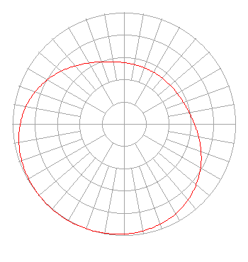 | ||||||||||||||||||
| Azimuth | Ratio | Azimuth | Ratio | Azimuth | Ratio | Azimuth | Ratio | ||||||||||||
| 0 | 0.549 | 10 | 0.540 | 20 | 0.535 | 30 | 0.534 | ||||||||||||
| 40 | 0.535 | 50 | 0.540 | 60 | 0.549 | 70 | 0.566 | ||||||||||||
| 80 | 0.592 | 90 | 0.630 | 100 | 0.679 | 110 | 0.735 | ||||||||||||
| 120 | 0.792 | 130 | 0.845 | 140 | 0.892 | 150 | 0.929 | ||||||||||||
| 160 | 0.956 | 170 | 0.975 | 180 | 0.987 | 190 | 0.995 | ||||||||||||
| 200 | 0.999 | 210 | 1.000 | 220 | 0.999 | 230 | 0.995 | ||||||||||||
| 240 | 0.987 | 250 | 0.975 | 260 | 0.956 | 270 | 0.929 | ||||||||||||
| 280 | 0.892 | 290 | 0.845 | 300 | 0.792 | 310 | 0.735 | ||||||||||||
| 320 | 0.679 | 330 | 0.630 | 340 | 0.592 | 350 | 0.566 | ||||||||||||
Structure Registration Number 1058791 [ASR Heights Differ from K203FE Application] Structure Type: TOWER Registered To: Pinnacle Towers LLC Structure Address: 13050 N 536 Road Tahlequah, OK County Name: Cherokee County ASR Issued: 05/06/2016 Date Built: 11/16/1988 Site Elevation: 324.9 m (1066 ft.) Structure Height: 91.4 m (300 ft.) Height Overall: 97.5 m (320 ft.) Overall Height AMSL: 422.4 m (1386 ft.) FAA Determination: 12/13/2011 FAA Study #: 2011-ASW-6418-OE FAA Circular #: 70/7460-1G Paint & Light FAA Chapters: 3, 4, 5, 9 PRIOR STUDY 2010-ASW-4187-OE 35-59-18.9 N 94-56-19.9 W (NAD 83) 35-59-18.6 N 94-56-19.1 W (Converted to NAD 27) |
820 N Lasalle St Chicago, IL 60610-3214 Phone: 312-329-4438 | Date: 07/25/2011 Application Certifier THE MOODY BIBLE INSTITUTE OF CHICAGO 820 North Lasalle Boulevard Chicago, IL 60610-3284 Applicant JEFFREY D SOUTHMAYD Southmayd & Miller 4 Ocean Ridge Boulevard South Palm Coast, FL 32137 ATTORNEY JEFFREY D. SOUTHMAYD Southmayd & Miller 4 Ocean Ridge Boulevard South Palm Coast, FL 32137 | |||||||||||||||||