
FCCInfo.com
A Service of Cavell, Mertz & Associates, Inc.
(855) FCC-INFO
|
|
K292HH from 01/09/2014 |
|
|
||||||||||||||||
|
|
K292HH Channel: 292D 106.3 MHz Portland, Oregon Service: FX - A translator or application for a translator. Facility ID: 142743 Fac. Service: FX Programming Delivery Method: Unspecified Status: License Application Accepted: 09/13/2018 Application Granted: 10/02/2018 File Number: BLFT-20180913AAQ License Expires: 00/00/0000 Prefix Type: This is a license for a translator Application Type: License To Cover FCC Website Links: LMS Facility Details This Application CDBS Application Other K292HH Applications Other K292HH Applications in CDBS Including Superseded Applications Mailing Address Correspondence for K292HH Correspondence related to application BLFT-20180913AAQ Service Contour - Open Street Map or USGS Map (60 dBu) Service Contour - KML / Google Earth (60 dBu) Class: D, A Noncommercial educational operating with no more than 10W Site Location: 45-29-19.4 N 122-41-44.3 W (NAD 83) Site Location: 45-29-20.0 N 122-41-40.0 W (Converted to NAD 27) Effective Radiated Power: 0.099 kW Transmitter Output Power: 0.18 kW Antenna Center HAAT: 0 m Antenna Center AMSL: 432 m (1417 ft.) Antenna Center HAG: 122 m (400 ft.) Site Elevation: 310 m. (1017 ft.) Height Overall*: 189 m (620 ft.) (* As Filed In This Application, may differ from ASR Data, Below.) Directional Antenna Antenna Make/Model: None Antenna ID: 133047 Polarization:
| ||||||||||||||||||
| Antenna Data for Antenna Id: 133047 K292HH FX File: BLFT-20180913AAQ None - Service: FX | 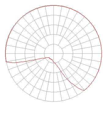 | ||||||||||||||||||
| Azimuth | Ratio | Azimuth | Ratio | Azimuth | Ratio | Azimuth | Ratio | ||||||||||||
| 0 | 1.000 | 10 | 1.000 | 20 | 1.000 | 30 | 1.000 | ||||||||||||
| 40 | 1.000 | 50 | 1.000 | 60 | 1.000 | 70 | 1.000 | ||||||||||||
| 80 | 1.000 | 90 | 1.000 | 100 | 1.000 | 110 | 1.000 | ||||||||||||
| 120 | 1.000 | 130 | 1.000 | 140 | 1.000 | 150 | 0.680 | ||||||||||||
| 160 | 0.337 | 170 | 0.212 | 180 | 0.180 | 190 | 0.140 | ||||||||||||
| 200 | 0.130 | 210 | 0.130 | 220 | 0.130 | 230 | 0.130 | ||||||||||||
| 240 | 0.180 | 250 | 0.350 | 260 | 1.000 | 270 | 1.000 | ||||||||||||
| 280 | 1.000 | 290 | 1.000 | 300 | 1.000 | 310 | 1.000 | ||||||||||||
| 320 | 1.000 | 330 | 1.000 | 340 | 1.000 | 350 | 1.000 | ||||||||||||
Structure Registration Number 1033770 Structure Type: TOWER Registered To: Stonehenge Towers, LLC Structure Address: 4700 Council Crest Dr Portland, OR County Name: Multnomah County ASR Issued: 07/09/2008 Date Built: 06/05/1991 Site Elevation: 310.3 m (1018 ft.) Structure Height: 153.9 m (505 ft.) Height Overall: 189 m (620 ft.) Overall Height AMSL: 499.3 m (1638 ft.) FAA Determination: 08/13/2002 FAA Study #: 2002-ANM-1415-OE FAA Circular #: 70/7460-1K Paint & Light FAA Chapters: 3, 4, 5, 12 Removed expiration date from determination. Scenario 1./jjs/case#635066 45-29-19.4 N 122-41-44.4 W (NAD 83) 45-29-20.0 N 122-41-40.1 W (Converted to NAD 27) |
4880 Santa Rosa Road Camarillo, CA 93012 Phone: 805-987-0400 | Date: 09/13/2018 Application Certifier SALEM MEDIA OF OREGON, INC. 4880 Santa Rosa Road Camarillo, CA 93012 Applicant WILLIAM J. GETZ Carl T. Jones Corporation 7901 Yarnwood Court Springfield, VA 22153 CONSULTING ENGINEER KATHLEEN A. KIRBY Wiley Rein Llp 1776 K Street, Nw Washington, DC 20006 | |||||||||||||||||