
FCCInfo.com
A Service of Cavell, Mertz & Associates, Inc.
(855) FCC-INFO
|
|
|
|  |
|
|||||||||||||||
|
|
KMOJ Channel: 210C3 89.9 MHz Minneapolis, Minnesota Service: FM - A full-service FM station or application. Facility ID: 14679 Fac. Service: FM Analog & Digital Status: License Application Accepted: 04/29/2011 Application Granted: 05/11/2011 File Number: BLED-20110429ABR License Expires: 00/00/0000 Prefix Type: This is a license for a noncommercial educational FM station Application Type: License To Cover FCC Website Links: LMS Facility Details This Application CDBS Application Other KMOJ Applications Other KMOJ Applications in CDBS Including Superseded Applications Mailing Address Correspondence for KMOJ Correspondence related to application BLED-20110429ABR Service Contour - Open Street Map or USGS Map (60 dBu) Service Contour - KML / Google Earth (60 dBu) Public Inspection Files History Cards for KMOJ Facility Type: NON-COMMERCIAL EDUC. FM Class: C3, A Zone II station; with 6kW-25kW ERP and a class contour distance 28km-39km Site Location: 45-04-06.9 N 93-10-34.8 W (NAD 83) Site Location: 45-04-07.0 N 93-10-34.0 W (Converted to NAD 27) Effective Radiated Power: 6.2 kW Transmitter Output Power: 2.58 kW Antenna Center HAAT: 120 m (394 ft.) Antenna Center AMSL: 397 m (1302 ft.) Antenna Center HAG: 116 m (381 ft.) Calculated Site Elevation: 281 m. (922 ft.) Height Overall*: 191 m (627 ft.) (* As Filed In This Application, may differ from ASR Data, Below.) Directional Antenna Antenna Make/Model: Electronics Research Inc. LP-4E-DA-HW Antenna ID: 104112 Polarization: | ||||||||||||||||||
| Antenna Data for Antenna Id: 104112 KMOJ FM File: BLED-20110429ABR Electronics Research Inc. - LP-4E-DA-HW Service: FM | 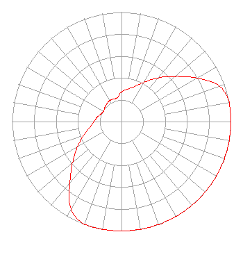 | ||||||||||||||||||
| Azimuth | Ratio | Azimuth | Ratio | Azimuth | Ratio | Azimuth | Ratio | ||||||||||||
| 0 | 0.270 | 10 | 0.300 | 20 | 0.340 | 30 | 0.415 | ||||||||||||
| 40 | 0.522 | 50 | 0.642 | 60 | 0.794 | 70 | 0.950 | ||||||||||||
| 80 | 1.000 | 90 | 1.000 | 100 | 1.000 | 110 | 1.000 | ||||||||||||
| 120 | 1.000 | 130 | 1.000 | 140 | 1.000 | 150 | 1.000 | ||||||||||||
| 160 | 1.000 | 170 | 1.000 | 180 | 1.000 | 190 | 1.000 | ||||||||||||
| 200 | 1.000 | 210 | 0.925 | 220 | 0.735 | 230 | 0.584 | ||||||||||||
| 240 | 0.464 | 250 | 0.369 | 260 | 0.294 | 270 | 0.251 | ||||||||||||
| 280 | 0.226 | 290 | 0.200 | 300 | 0.190 | 310 | 0.200 | ||||||||||||
| 320 | 0.210 | 330 | 0.220 | 340 | 0.220 | 350 | 0.220 | ||||||||||||
Structure Registration Number 1060523 [ASR Heights Differ from KMOJ Application] Structure Type: TOWER Registered To: ARDEN TOWERS INC Structure Address: 1777 14th St Arden Hills, MN County Name: Ramsey County ASR Issued: 04/19/2011 Date Built: 04/20/2011 Site Elevation: 281 m (922 ft.) Structure Height: 190.5 m (625 ft.) Height Overall: 190.5 m (625 ft.) Overall Height AMSL: 471.5 m (1547 ft.) FAA Determination: 03/10/2011 FAA Study #: 2011-AGL-1809-OE Paint & Light FAA Chapters: A2, H, 1, 3, 4, 13, 21, 23 PRIOR STUDY 1980-AGL-1037-OE 45-04-07.1 N 93-10-35.1 W (NAD 83) 45-04-07.2 N 93-10-34.3 W (Converted to NAD 27) |
2123 W. Broadway Ave. Minneapolis, MN 55411 Phone: 612-377-0594 Not-for-Profit | Date: 04/29/2011 Application Certifier CENTER FOR COMMUNICATION & DEVELOPMENT 2123 W. Broadway Ave. Minneapolis, MN 55411-1807 Applicant DAVID ERNEWEIN C/o Kmoj 2123 W, Broadway Ave. Minneapolis, MN 55411-1807 CHIEF ENGINEER PETER TANNENWALD Fletcher, Heald & Hildredth, P.l.c. | |||||||||||||||||