
FCCInfo.com
A Service of Cavell, Mertz & Associates, Inc.
(855) FCC-INFO
|
|
|
|  |
|
|||||||||||||||
|
|
WLFH Channel: 205C2 88.9 MHz Claxton, Georgia Service: FM - A full-service FM station or application. Facility ID: 176341 Fac. Service: FM Status: License Application Accepted: 08/23/2013 Application Granted: 03/20/2014 File Number: BLED-20130823ADB License Expires: 00/00/0000 Prefix Type: This is a license for a noncommercial educational FM station Application Type: Amendment FCC Website Links: LMS Facility Details This Application CDBS Application Other WLFH Applications Other WLFH Applications in CDBS Including Superseded Applications Mailing Address Correspondence for WLFH Correspondence related to application BLED-20130823ADB Service Contour - Open Street Map or USGS Map (60 dBu) Service Contour - KML / Google Earth (60 dBu) Public Inspection Files Facility Type: NON-COMMERCIAL EDUC. FM Class: C2, A Zone II station; with 25kW-50kW ERP and a class contour distance 39km-52km Site Location: 32-18-06.7 N 81-49-56.4 W (NAD 83) Site Location: 32-18-06.0 N 81-49-57.0 W (Converted to NAD 27) Effective Radiated Power: 1.2 kW Horiz. ; 45 kW Vert. Transmitter Output Power: 7.2 kW Antenna Center HAAT: 76 m (249 ft.) Antenna Center AMSL: 123 m (404 ft.) Antenna Center HAG: 79 m (259 ft.) Calculated Site Elevation: 44 m. (144 ft.) Height Overall*: 93 m (305 ft.) (* As Filed In This Application, may differ from ASR Data, Below.) Directional Antenna Antenna Make/Model: Shivley 6025-3-2/2/2/2 Slant 12-Special DA, 3 bay Antenna ID: 89261 Polarization: | ||||||||||||||||||
| Antenna Data for Antenna Id: 89261 WLFH FM File: BLED-20130823ADB Shivley - 6025-3-2/2/2/2 Slant 12-Special DA, 3 bay Service: FM | 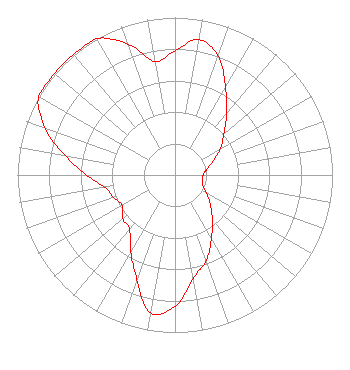 | ||||||||||||||||||
| Azimuth | Ratio | Azimuth | Ratio | Azimuth | Ratio | Azimuth | Ratio | ||||||||||||
| 0 | 0.788 | 10 | 0.873 | 20 | 0.804 | 30 | 0.640 | ||||||||||||
| 40 | 0.509 | 50 | 0.405 | 60 | 0.332 | 70 | 0.256 | ||||||||||||
| 80 | 0.204 | 90 | 0.178 | 100 | 0.178 | 110 | 0.186 | ||||||||||||
| 120 | 0.233 | 130 | 0.293 | 140 | 0.368 | 150 | 0.462 | ||||||||||||
| 160 | 0.578 | 170 | 0.666 | 180 | 0.833 | 190 | 0.889 | ||||||||||||
| 200 | 0.707 | 210 | 0.562 | 220 | 0.449 | 230 | 0.434 | ||||||||||||
| 240 | 0.386 | 250 | 0.416 | 260 | 0.449 | 270 | 0.562 | ||||||||||||
| 280 | 0.707 | 290 | 0.881 | 300 | 1.000 | 310 | 1.000 | ||||||||||||
| 320 | 1.000 | 330 | 1.000 | 340 | 0.885 | 350 | 0.731 | ||||||||||||
Structure Registration Number 1215193 Structure Type: GTOWER Registered To: American Towers LLC Structure Address: 2100 Jo Dan Road (#24697) Register, GA County Name: Bulloch County ASR Issued: 06/24/2016 Date Built: 11/29/2000 Site Elevation: 44.2 m (145 ft.) Structure Height: 91.4 m (300 ft.) Height Overall: 92.9 m (305 ft.) Overall Height AMSL: 137.1 m (450 ft.) FAA Determination: 09/05/2013 FAA Study #: 2013-ASO-6441-OE FAA Circular #: 70/7460-1K Paint & Light FAA Chapters: 4, 8, 12 32-18-06.5 N 81-49-56.6 W (NAD 83) 32-18-05.8 N 81-49-57.2 W (Converted to NAD 27) |
P.o. Box 7217 Lakeland, FL 33807-7217 Phone: 863-644-3464 Not-for-Profit | Date: 08/23/2013 Application Certifier RADIO TRAINING NETWORK, INC. P.o. Box 7217 Lakeland, FL 33807-7217 Applicant R. STUART GRAHAM Graham Brock, Inc. P. O. Box 24466 St. Simons Island, GA 31522-7466 TECHNICAL CONSULTANT A. WRAY FITCH III Gammon & Grange, P.c. | |||||||||||||||||