
FCCInfo.com
A Service of Cavell, Mertz & Associates, Inc.
(855) FCC-INFO
|
|
K250BV from 11/03/2015 |
|
|
||||||||||||||||
|
|
K250BV Channel: 250D 97.9 MHz Ventura, California Service: FX - A translator or application for a translator. Facility ID: 143657 Fac. Service: FX Programming Delivery Method: Unspecified Status: License (Licensed And Silent) Application Accepted: 11/02/2018 Application Granted: 02/21/2020 File Number: BLFT-20181102AAM License Expires: 00/00/0000 Prefix Type: This is a license for a translator Application Type: License To Cover FCC Website Links: LMS Facility Details This Application CDBS Application Other K250BV Applications Other K250BV Applications in CDBS Including Superseded Applications Mailing Address Correspondence for K250BV Correspondence related to application BLFT-20181102AAM Service Contour - Open Street Map or USGS Map (60 dBu) Service Contour - KML / Google Earth (60 dBu) Class: D, A Noncommercial educational operating with no more than 10W Site Location: 34-14-13.0 N 119-12-12.4 W (NAD 83) Site Location: 34-14-13.0 N 119-12-09.0 W (Converted to NAD 27) Effective Radiated Power: 0.17 kW Transmitter Output Power: 0.094 kW Antenna Center HAAT: 0 m Antenna Center AMSL: 75 m (246 ft.) Antenna Center HAG: 60 m (197 ft.) Site Elevation: 15 m. (49 ft.) Height Overall*: 96 m (315 ft.) (* As Filed In This Application, may differ from ASR Data, Below.) Directional Antenna Antenna Make/Model: None Antenna ID: 126159 Polarization:
| ||||||||||||||||||
| Antenna Data for Antenna Id: 126159 K250BV FX File: BLFT-20181102AAM None - Service: FX Pattern and Field Values Include a 180° Clockwise Rotation | 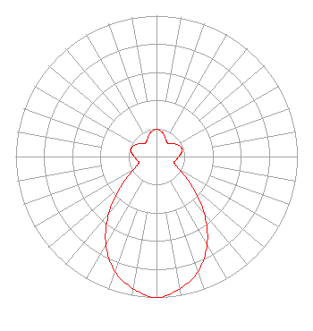 | ||||||||||||||||||
| Azimuth | Ratio | Azimuth | Ratio | Azimuth | Ratio | Azimuth | Ratio | ||||||||||||
| 0 | 0.193 | 10 | 0.182 | 20 | 0.160 | 30 | 0.135 | ||||||||||||
| 40 | 0.123 | 50 | 0.140 | 60 | 0.171 | 70 | 0.187 | ||||||||||||
| 80 | 0.181 | 90 | 0.157 | 100 | 0.142 | 110 | 0.134 | ||||||||||||
| 120 | 0.190 | 130 | 0.329 | 140 | 0.528 | 150 | 0.718 | ||||||||||||
| 160 | 0.866 | 170 | 0.952 | 180 | 1.000 | 190 | 0.952 | ||||||||||||
| 200 | 0.866 | 210 | 0.718 | 220 | 0.528 | 230 | 0.329 | ||||||||||||
| 240 | 0.190 | 250 | 0.134 | 260 | 0.142 | 270 | 0.157 | ||||||||||||
| 280 | 0.181 | 290 | 0.187 | 300 | 0.171 | 310 | 0.140 | ||||||||||||
| 320 | 0.123 | 330 | 0.135 | 340 | 0.160 | 350 | 0.182 | ||||||||||||
Structure Registration Number 1019626 [ASR Heights Differ from K250BV Application] Structure Type: 4TA1 Registered To: GOLD COAST BROADCASTING COMPANY Structure Address: Twr 1 - 6150 Olivas Park Dr Ventura, CA County Name: Ventura County ASR Issued: 03/12/1999 Date Built: 04/02/1997 Site Elevation: 15.2 m (50 ft.) Structure Height: 94.6 m (310 ft.) Height Overall: 95.5 m (313 ft.) Overall Height AMSL: 110.7 m (363 ft.) FAA Determination: 04/02/1997 FAA Study #: 97-AWP-0830-OE FAA Circular #: 70/7460-1J Paint & Light FAA Chapters: 3, 4, 5, 13 4 TOWER ARRAY. TOWER 1 (313') RED LIGHTS PAINT. TOWERS 2, 3 & 4 (156') HAVE NO OM&L. 34-14-13.0 N 119-12-12.0 W (NAD 83) 34-14-13.0 N 119-12-08.6 W (Converted to NAD 27) |
715 Broadway Suite 320 Santa Monica, CA 90401 Phone: 310-451-4430 Limited Liability Partnership | Date: 11/02/2018 Application Certifier GOLD COAST BROADCASTING LLC 715 Broadway Suite 320 Santa Monica, CA 90401 Applicant JEREMY D. RUCK, PE Jeremy Ruck & Associates, Inc. P.o. Box 415 Canton, IL 61520 CONSULTING ENGINEER DAVID D. OXENFORD Wilkinson Barker Knauer Llp 1800 M Street, N.w. Suite 800n Washington, DC 20036 | |||||||||||||||||