
FCCInfo.com
A Service of Cavell, Mertz & Associates, Inc.
(855) FCC-INFO
|
|
K287FG from 07/02/2004 |
|
|
||||||||||||||||
|
|
K287FG Channel: 287D 105.3 MHz Austin, Texas Service: FX - A translator or application for a translator. Facility ID: 148213 Fac. Service: FX Programming Delivery Method: Unspecified Status: License Application Accepted: 03/20/2013 Application Granted: 04/10/2013 File Number: BLFT-20130320AEI License Expires: 00/00/0000 Prefix Type: This is a license for a translator Application Type: License To Cover FCC Website Links: LMS Facility Details This Application CDBS Application Other K287FG Applications Other K287FG Applications in CDBS Including Superseded Applications Mailing Address Correspondence for K287FG Correspondence related to application BLFT-20130320AEI Service Contour - Open Street Map or USGS Map (60 dBu) Service Contour - KML / Google Earth (60 dBu) Class: D, A Noncommercial educational operating with no more than 10W Site Location: 30-19-23.7 N 97-47-59.0 W (NAD 83) Site Location: 30-19-23.0 N 97-47-58.0 W (Converted to NAD 27) Effective Radiated Power: 0.075 kW Transmitter Output Power: 0.61 kW Antenna Center HAAT: 331.8 m Horiz.; 0 m Vert. Antenna Center AMSL: 551 m (1808 ft.) Antenna Center HAG: 302 m (991 ft.) Site Elevation: 249 m. (817 ft.) Height Overall*: 375 m (1230 ft.) (* As Filed In This Application, may differ from ASR Data, Below.) Directional Antenna Antenna Make/Model: None Antenna ID: 111740 Polarization:
| ||||||||||||||||||
| Antenna Data for Antenna Id: 111740 K287FG FX File: BLFT-20130320AEI None - Service: FX Pattern and Field Values Include a 338° Clockwise Rotation | 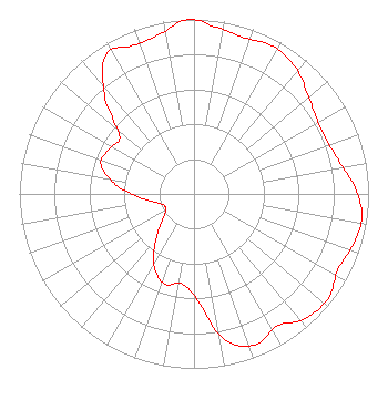 | ||||||||||||||||||
| Azimuth | Ratio | Azimuth | Ratio | Azimuth | Ratio | Azimuth | Ratio | ||||||||||||
| 8 | 0.962 | 18 | 0.941 | 28 | 0.959 | 38 | 0.933 | ||||||||||||
| 48 | 0.871 | 58 | 0.825 | 68 | 0.818 | 78 | 0.855 | ||||||||||||
| 88 | 0.923 | 98 | 0.972 | 108 | 0.955 | 118 | 0.932 | ||||||||||||
| 128 | 0.975 | 138 | 0.957 | 148 | 0.895 | 158 | 0.934 | ||||||||||||
| 168 | 0.854 | 178 | 0.612 | 188 | 0.519 | 198 | 0.542 | ||||||||||||
| 208 | 0.481 | 218 | 0.363 | 228 | 0.254 | 238 | 0.192 | ||||||||||||
| 248 | 0.181 | 258 | 0.227 | 268 | 0.333 | 278 | 0.467 | ||||||||||||
| 288 | 0.561 | 298 | 0.549 | 308 | 0.542 | 318 | 0.766 | ||||||||||||
| 328 | 0.945 | 338 | 0.918 | 348 | 0.936 | 358 | 1.000 | ||||||||||||
Structure Registration Number 1013180 Structure Type: GTOWER Registered To: American Towers LLC Structure Address: 5319 Buckman Mountain Road (007000) Austin, TX County Name: Travis County ASR Issued: 06/17/2016 Date Built: 10/08/1997 Site Elevation: 249.3 m (818 ft.) Structure Height: 351.1 m (1152 ft.) Height Overall: 374.6 m (1229 ft.) Overall Height AMSL: 623.9 m (2047 ft.) FAA Determination: 06/04/2013 FAA Study #: 2013-ASW-3758-OE FAA Circular #: 70/7460-1K Paint & Light FAA Chapters: 3, 4, 5, 12 PRIOR STUDY 2013-ASW-2050-OE 30-19-23.8 N 97-47-59.5 W (NAD 83) 30-19-23.1 N 97-47-58.5 W (Converted to NAD 27) |
3839 Bee Caves Rd. Ste.100 Austin, TX 78746 Phone: 512-480-8693 | Date: 03/20/2013 Application Certifier JAMES S. BUMPOUS D/B/A BIG BEND BROADCASTING 317 Nautilus Ave Lakeway, TX 78738-1010 Applicant GREG SHAPIRO Rf Services Inc. 7301 Ranch Road 620 N. Suite 155 Austin, TX 78726 CONSULTING ENGINEER LEE J. PELTZMAN Shainis & Peltzman Chartered 1850 M Street Nw #240 Washington, DC 20036 | |||||||||||||||||