
FCCInfo.com
A Service of Cavell, Mertz & Associates, Inc.
(855) FCC-INFO
|
|
W276DB from 12/02/2013 |
|
|
||||||||||||||||
|
|
W276DB Channel: 276D 103.1 MHz Rochester Hills, Michigan Service: FX - A translator or application for a translator. Facility ID: 142079 Fac. Service: FX Programming Delivery Method: Unspecified Status: License Application Accepted: 11/28/2016 Application Granted: 12/02/2016 File Number: BLFT-20161128ADU License Expires: 00/00/0000 Prefix Type: This is a license for a translator Application Type: License To Cover FCC Website Links: LMS Facility Details This Application CDBS Application Other W276DB Applications Other W276DB Applications in CDBS Including Superseded Applications Mailing Address Correspondence for W276DB Correspondence related to application BLFT-20161128ADU Service Contour - Open Street Map or USGS Map (60 dBu) Service Contour - KML / Google Earth (60 dBu) Class: D, A Noncommercial educational operating with no more than 10W Site Location: 42-38-55.0 N 83-04-31.0 W (NAD 83) Site Location: 42-38-54.9 N 83-04-31.3 W (Converted to NAD 27) Effective Radiated Power: 0.25 kW Transmitter Output Power: 0.25 kW Antenna Center HAAT: 0 m Antenna Center AMSL: 314 m (1030 ft.) Antenna Center HAG: 101 m (331 ft.) Site Elevation: 213 m. (699 ft.) Height Overall*: 128 m (420 ft.) (* As Filed In This Application, may differ from ASR Data, Below.) Directional Antenna Antenna Make/Model: None Antenna ID: 123360 Polarization:
| ||||||||||||||||||
| Antenna Data for Antenna Id: 123360 W276DB FX File: BLFT-20161128ADU None - Service: FX | 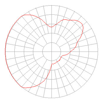 | ||||||||||||||||||
| Azimuth | Ratio | Azimuth | Ratio | Azimuth | Ratio | Azimuth | Ratio | ||||||||||||
| 0 | 0.528 | 10 | 0.597 | 20 | 0.727 | 30 | 0.781 | ||||||||||||
| 40 | 0.866 | 50 | 0.877 | 60 | 0.758 | 70 | 0.597 | ||||||||||||
| 80 | 0.522 | 90 | 0.414 | 100 | 0.347 | 110 | 0.259 | ||||||||||||
| 120 | 0.240 | 130 | 0.248 | 140 | 0.254 | 150 | 0.250 | ||||||||||||
| 160 | 0.261 | 170 | 0.270 | 180 | 0.294 | 190 | 0.560 | ||||||||||||
| 200 | 0.744 | 210 | 0.889 | 220 | 1.000 | 230 | 1.000 | ||||||||||||
| 240 | 1.000 | 250 | 1.000 | 260 | 1.000 | 270 | 1.000 | ||||||||||||
| 280 | 1.000 | 290 | 1.000 | 300 | 1.000 | 310 | 1.000 | ||||||||||||
| 320 | 1.000 | 330 | 0.910 | 340 | 0.765 | 350 | 0.596 | ||||||||||||
Structure Registration Number 1064760 Structure Type: TOWER Registered To: Peake Holdings, LLC Structure Address: 48181 Ryan Rd Shelby Township, MI County Name: Macomb County ASR Issued: 09/02/2009 Date Built: 09/01/1980 Site Elevation: 213.4 m (700 ft.) Structure Height: 118.9 m (390 ft.) Height Overall: 128 m (420 ft.) Overall Height AMSL: 341.4 m (1120 ft.) FAA Determination: 01/01/1984 FAA Study #: 84-AGL-2491-OE Paint & Light FAA Chapters: 1, 3, 12, 21 RED LIGHTS/PAINT 42-38-55.0 N 83-04-31.0 W (NAD 83) 42-38-54.9 N 83-04-31.3 W (Converted to NAD 27) |
680 Barclay Boulevard Lincolnshire, IL 60069 Phone: 877-291-0123 Not-for-Profit | Date: 11/28/2016 Application Certifier FAMILY LIFE BROADCASTING SYSTEM 7355 North Oracle Road Tucson, AZ 85704 Applicant MICHAEL K. BRINKS 7355 N. Oracle Road Tucson, AZ 85704 DIRECTOR OF SIGNAL DEVELOPMENT AND FCC COMPLIANCE PETER GUTMANN Womble Carlyle Sandridge & Rice, Llp 1200 Nineteenth St., Nw Suite 500 Washington, DC 20036 | |||||||||||||||||