
FCCInfo.com
A Service of Cavell, Mertz & Associates, Inc.
(855) FCC-INFO
|
|
|
|  |
|
|||||||||||||||
|
|
KTKE Channel: 268A 101.5 MHz Truckee, California Service: FM - A full-service FM station or application. Facility ID: 88673 Fac. Service: FM Status: License 73.215 Station Application Accepted: 05/29/2003 Application Granted: 08/15/2003 File Number: BLH-20030529AFZ License Expires: 00/00/0000 Prefix Type: This is a license for a commercial FM station Application Type: License To Cover FCC Website Links: LMS Facility Details This Application CDBS Application Other KTKE Applications Other KTKE Applications in CDBS Including Superseded Applications Mailing Address Correspondence for KTKE Correspondence related to application BLH-20030529AFZ Service Contour - Open Street Map or USGS Map (60 dBu) Service Contour - KML / Google Earth (60 dBu) Public Inspection Files Facility Type: FM STATION Class: A, A Zone I; I-A; or II station; with 0.1kW-6kW ERP and a class contour distance <=28km Site Location: 39-14-28.7 N 120-08-23.7 W (NAD 83) Site Location: 39-14-29.0 N 120-08-20.0 W (Converted to NAD 27) Effective Radiated Power: 0.14 kW Transmitter Output Power: 0.157 kW Antenna Center HAAT: 606 m (1988 ft.) Antenna Center AMSL: 2648 m (8688 ft.) Antenna Center HAG: 23 m (75 ft.) Calculated Site Elevation: 2625 m. (8612 ft.) Height Overall*: 0 m (* As Filed In This Application, may differ from ASR Data, Below.) Directional Antenna Antenna Make/Model: Shivley 6810NX-1R-DA Antenna ID: 60796 Polarization: | ||||||||||||||||||
| Antenna Data for Antenna Id: 60796 KTKE FM File: BLH-20030529AFZ Shivley - 6810NX-1R-DA Service: FM | 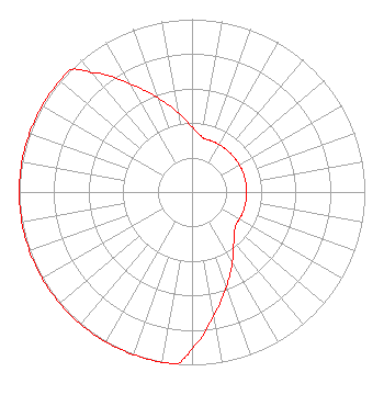 | ||||||||||||||||||
| Azimuth | Ratio | Azimuth | Ratio | Azimuth | Ratio | Azimuth | Ratio | ||||||||||||
| 0 | 0.376 | 10 | 0.325 | 15 | 0.316 | 20 | 0.316 | ||||||||||||
| 30 | 0.316 | 40 | 0.316 | 50 | 0.316 | 60 | 0.316 | ||||||||||||
| 70 | 0.316 | 80 | 0.316 | 90 | 0.316 | 100 | 0.316 | ||||||||||||
| 110 | 0.316 | 120 | 0.316 | 125 | 0.316 | 130 | 0.325 | ||||||||||||
| 140 | 0.376 | 150 | 0.468 | 160 | 0.582 | 170 | 0.725 | ||||||||||||
| 180 | 0.902 | 185 | 1.000 | 190 | 1.000 | 200 | 1.000 | ||||||||||||
| 210 | 1.000 | 220 | 1.000 | 230 | 1.000 | 240 | 1.000 | ||||||||||||
| 250 | 1.000 | 260 | 1.000 | 270 | 1.000 | 280 | 1.000 | ||||||||||||
| 290 | 1.000 | 300 | 1.000 | 310 | 1.000 | 315 | 1.000 | ||||||||||||
| 320 | 0.902 | 330 | 0.725 | 340 | 0.582 | 350 | 0.468 | ||||||||||||
Structure Registration Number 1026416 [ASR Heights Differ from KTKE Application] Structure Type: TOWER Registered To: Pinnacle Towers LLC Structure Address: 8670 ?113? Road Tahoe City, CA County Name: Placer County ASR Issued: 05/06/2016 Date Built: 07/23/1996 Site Elevation: 2625.5 m (8614 ft.) Structure Height: 37.5 m (123 ft.) Height Overall: 42.4 m (139 ft.) Overall Height AMSL: 2667.9 m (8753 ft.) FAA Determination: 11/26/2007 FAA Study #: 2007-AWP-6884-OE Paint & Light FAA Chapters: NONE 39-14-29.3 N 120-08-24.2 W (NAD 83) 39-14-29.6 N 120-08-20.5 W (Converted to NAD 27) |
11890 Donner Pass Rd. Ste 2 Truckee, CA 96161 Phone: 530-559-4800 Limited Liability Company | Date: 05/29/2003 Application Certifier TRUCKSTER BROADCASTING, INC. 2307 Princess Ann Street Greensboro, NC 27408 Applicant LAURA M. MIZRAHI Communications Technologies, Inc. P.o. Box 1130 Marlton, NJ 08053 TECHNICAL CONSULTANT A. WRAY FITCH III Gammon & Grange, P.c. | |||||||||||||||||
| |||||||||||||||||||