
FCCInfo.com
A Service of Cavell, Mertz & Associates, Inc.
(855) FCC-INFO
|
|
K261ES from 07/27/2004 |
|
|
||||||||||||||||
|
|
K261ES Channel: 261D 100.1 MHz Las Vegas, Nevada Service: FX - A translator or application for a translator. Facility ID: 149465 Fac. Service: FX Programming Delivery Method: Unspecified Status: License Application Accepted: 09/27/2018 Application Granted: 10/11/2018 File Number: BLFT-20180927ABY License Expires: 00/00/0000 Prefix Type: This is a license for a translator Application Type: License To Cover FCC Website Links: LMS Facility Details This Application CDBS Application Other K261ES Applications Other K261ES Applications in CDBS Including Superseded Applications Mailing Address Correspondence for K261ES Correspondence related to application BLFT-20180927ABY Service Contour - Open Street Map or USGS Map (60 dBu) Service Contour - KML / Google Earth (60 dBu) Class: D, A Noncommercial educational operating with no more than 10W Site Location: 36-09-22.1 N 115-15-35.0 W (NAD 83) Site Location: 36-09-22.2 N 115-15-32.0 W (Converted to NAD 27) Effective Radiated Power: 0 kW Horiz. ; 0.04 kW Vert. Transmitter Output Power: 0.01 kW Antenna Center HAAT: 0 m Antenna Center AMSL: 0 m Horiz.; 858 m Vert. Antenna Center HAG: 0 m Horiz.; 90 m Vert. Site Elevation: 768 m. (2520 ft.) Height Overall*: 99 m (325 ft.) (* As Filed In This Application, may differ from ASR Data, Below.) Directional Antenna Antenna Make/Model: None Antenna ID: 127935 Polarization:
| ||||||||||||||||||
| Antenna Data for Antenna Id: 127935 K261ES FX File: BLFT-20180927ABY None - Service: FX Pattern and Field Values Include a 10° Clockwise Rotation | 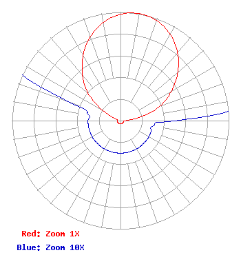 | ||||||||||||||||||
| Azimuth | Ratio | Azimuth | Ratio | Azimuth | Ratio | Azimuth | Ratio | ||||||||||||
| 0 | 0.980 | 10 | 1.000 | 20 | 0.980 | 30 | 0.916 | ||||||||||||
| 40 | 0.818 | 50 | 0.690 | 60 | 0.544 | 70 | 0.390 | ||||||||||||
| 80 | 0.190 | 90 | 0.050 | 100 | 0.030 | 110 | 0.030 | ||||||||||||
| 120 | 0.030 | 130 | 0.030 | 140 | 0.030 | 150 | 0.030 | ||||||||||||
| 160 | 0.030 | 170 | 0.030 | 180 | 0.030 | 190 | 0.030 | ||||||||||||
| 200 | 0.030 | 210 | 0.030 | 220 | 0.030 | 230 | 0.030 | ||||||||||||
| 240 | 0.030 | 250 | 0.030 | 260 | 0.030 | 270 | 0.030 | ||||||||||||
| 280 | 0.030 | 290 | 0.050 | 300 | 0.190 | 310 | 0.390 | ||||||||||||
| 320 | 0.544 | 330 | 0.690 | 340 | 0.818 | 350 | 0.916 | ||||||||||||
Structure Registration Number 1219542 Structure Type: GTOWER Registered To: Las Vegas Broadcasters, Inc. Structure Address: Near Intersection Of Buffalo & Charleston Blvd Las Vegas, NV County Name: Clark County ASR Issued: 06/23/2014 Date Built: 01/01/1974 Site Elevation: 768.4 m (2521 ft.) Structure Height: 98.1 m (322 ft.) Height Overall: 99.1 m (325 ft.) Overall Height AMSL: 867.5 m (2846 ft.) FAA Determination: 05/29/2014 FAA Study #: 2014-AWP-2033-OE FAA Circular #: 70/7460-1K Paint & Light FAA Chapters: 3, 4, 5, 12 Removed expiration date from determination. Scenario 1./jjs/case#635066 36-09-22.1 N 115-15-35.0 W (NAD 83) 36-09-22.2 N 115-15-32.0 W (Converted to NAD 27) |
3185 S Highland Dr. Suite 13 Las Vegas, NV 89109-1029 Phone: 702-731-5588 | Date: 09/27/2018 Application Certifier LAS VEGAS BROADCASTERS, INC. 3185 South Highland Suite 13 Las Vegas, NV 89109 Applicant ROBERT H BRANCH JR 212 Honey Tree Lane Lynchburg, VA 24502 TECHNICAL CONSULTANT NATHANIEL J. HARDY, ESQ. Marashlian & Donahue, Llc The Commlaw Group 1420 Spring Hill Road Suite 401 Mclean, VA 22102 | |||||||||||||||||