
FCCInfo.com
A Service of Cavell, Mertz & Associates, Inc.
(855) FCC-INFO
|
|
|
|  |
|
|||||||||||||||
|
|
KISW Channel: 260C 99.9 MHz Seattle, Washington Service: FM - A full-service FM station or application. Facility ID: 47750 Fac. Service: FM Analog & Digital Status: License 73.215 Station Application Accepted: 07/30/2008 Application Granted: 08/25/2008 File Number: BLH-20080730AKM License Expires: 00/00/0000 Prefix Type: This is a license for a commercial FM station Application Type: License To Cover FCC Website Links: LMS Facility Details This Application CDBS Application Other KISW Applications Other KISW Applications in CDBS Including Superseded Applications Mailing Address Correspondence for KISW Correspondence related to application BLH-20080730AKM Service Contour - Open Street Map or USGS Map (60 dBu) Service Contour - KML / Google Earth (60 dBu) Public Inspection Files History Cards for KISW Facility Type: FM STATION Class: C, A Zone II station; with exactly 100kW ERP and a class contour distance 72km-92km Site Location: 47-30-13.4 N 121-58-33.4 W (NAD 83) Site Location: 47-30-14.0 N 121-58-29.0 W (Converted to NAD 27) Effective Radiated Power: 68 kW Transmitter Output Power: 18.3 kW Antenna Center HAAT: 707 m (2320 ft.) Antenna Center AMSL: 940 m (3084 ft.) Antenna Center HAG: 41 m (135 ft.) Calculated Site Elevation: 899 m. (2949 ft.) Height Overall*: 61 m (200 ft.) (* As Filed In This Application, may differ from ASR Data, Below.) Directional Antenna Antenna Make/Model: Electronics Research Inc. 1082-4CP-DA, 4 sections Antenna ID: 32029 Polarization: | ||||||||||||||||||
| Antenna Data for Antenna Id: 32029 KISW FM File: BLH-20080730AKM Electronics Research Inc. - 1082-4CP-DA, 4 sections Service: FM | 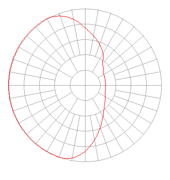 | ||||||||||||||||||
| Azimuth | Ratio | Azimuth | Ratio | Azimuth | Ratio | Azimuth | Ratio | ||||||||||||
| 0 | 0.750 | 10 | 0.650 | 20 | 0.560 | 30 | 0.470 | ||||||||||||
| 40 | 0.360 | 50 | 0.320 | 60 | 0.285 | 70 | 0.275 | ||||||||||||
| 80 | 0.270 | 90 | 0.270 | 100 | 0.275 | 110 | 0.280 | ||||||||||||
| 120 | 0.305 | 130 | 0.340 | 140 | 0.390 | 150 | 0.470 | ||||||||||||
| 160 | 0.585 | 170 | 0.725 | 180 | 0.865 | 190 | 0.965 | ||||||||||||
| 200 | 1.000 | 210 | 1.000 | 220 | 1.000 | 230 | 1.000 | ||||||||||||
| 240 | 1.000 | 250 | 1.000 | 260 | 1.000 | 270 | 1.000 | ||||||||||||
| 280 | 1.000 | 290 | 1.000 | 300 | 1.000 | 310 | 1.000 | ||||||||||||
| 320 | 1.000 | 330 | 1.000 | 340 | 0.960 | 350 | 0.875 | ||||||||||||
Structure Registration Number 1056823 Structure Type: LTOWER Registered To: American Towers LLC Structure Address: 3.75 Miles S.e. Of Issaquah, Wa - On West Tiger Mtn. (#273577) Issaquah, WA County Name: King County ASR Issued: 12/07/2016 Date Built: 04/03/1988 Site Elevation: 898.6 m (2948 ft.) Structure Height: 61 m (200 ft.) Height Overall: 61 m (200 ft.) Overall Height AMSL: 959.6 m (3148 ft.) FAA Determination: 12/05/2016 FAA Study #: 2016-ANM-3387-OE Paint & Light FAA Chapters: NONE PRIOR STUDY 2016-ANM-2649-OE 47-30-13.0 N 121-58-33.0 W (NAD 83) 47-30-13.6 N 121-58-28.6 W (Converted to NAD 27) |
2400 Market Street 4th Floor Philadelphia, PA 19103 Phone: 610-660-5610 Limited Liability Company | Date: 07/30/2008 Application Certifier ENTERCOM SEATTLE LICENSE, LLC 401 City Avenue, Suite 809 Bala Cynwyd, PA 19004 Applicant JOHN W. PRICE Entercom Corporate Engineering 1100 Olive Way, Suite 1650 Seattle, WA 98101 ASS'T TO VP-ENGINEERING BRIAN M. MADDEN Leventhal Senter & Lerman Pllc | |||||||||||||||||
|
| ||||||||||||||||||