
FCCInfo.com
A Service of Cavell, Mertz & Associates, Inc.
(855) FCC-INFO
|
|
|
|  |
|
||||||||||||||||||
|
|
WMXJ Channel: 274C0 102.7 MHz Pompano Beach, Florida Service: FM - A full-service FM station or application. Facility ID: 30840 Fac. Service: FM Analog & Digital Status: License Application Accepted: 02/25/2005 Application Granted: 03/21/2005 File Number: BLH-20050225AAL License Expires: 00/00/0000 Prefix Type: This is a license for a commercial FM station Application Type: License To Cover FCC Website Links: LMS Facility Details This Application CDBS Application Other WMXJ Applications Other WMXJ Applications in CDBS Including Superseded Applications Mailing Address Correspondence for WMXJ Correspondence related to application BLH-20050225AAL Service Contour - Open Street Map or USGS Map (60 dBu) Service Contour - KML / Google Earth (60 dBu) Public Inspection Files History Cards for WMXJ Facility Type: FM STATION Class: C0, C0 Site Location: 25-58-03.3 N 80-12-33.2 W (NAD 83) Site Location: 25-58-02.0 N 80-12-34.0 W (Converted to NAD 27) Effective Radiated Power: 100 kW Transmitter Output Power: 15.86 kW Antenna Center HAAT: 307 m (1007 ft.) Antenna Center AMSL: 308 m (1010 ft.) Antenna Center HAG: 306 m Horiz.; 308 m Vert. (1004 ft. Horiz. / 1010 ft. Vert.) Calculated Site Elevation: 2 m. (7 ft.) Height Overall*: 317.6 m (1042 ft.) (* As Filed In This Application, may differ from ASR Data, Below.) Directional Antenna Antenna Make/Model: Electronics Research Inc. COG1084-8CP-DA, eight sections Antenna ID: 64687 Polarization: | |||||||||||||||||||||
| Antenna Data for Antenna Id: 64687 WMXJ FM File: BLH-20050225AAL Electronics Research Inc. - COG1084-8CP-DA, eight sections Service: FM | 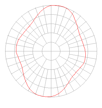 | |||||||||||||||||||||
| Azimuth | Ratio | Azimuth | Ratio | Azimuth | Ratio | Azimuth | Ratio | |||||||||||||||
| 0 | 0.990 | 10 | 1.000 | 20 | 0.990 | 30 | 0.930 | |||||||||||||||
| 40 | 0.840 | 45 | 0.800 | 50 | 0.760 | 60 | 0.720 | |||||||||||||||
| 70 | 0.710 | 80 | 0.720 | 90 | 0.745 | 100 | 0.760 | |||||||||||||||
| 110 | 0.760 | 120 | 0.732 | 130 | 0.715 | 135 | 0.720 | |||||||||||||||
| 140 | 0.725 | 150 | 0.780 | 160 | 0.860 | 170 | 0.940 | |||||||||||||||
| 180 | 0.990 | 190 | 1.000 | 200 | 0.990 | 210 | 0.940 | |||||||||||||||
| 220 | 0.860 | 225 | 0.820 | 230 | 0.780 | 240 | 0.725 | |||||||||||||||
| 250 | 0.715 | 260 | 0.730 | 270 | 0.760 | 280 | 0.760 | |||||||||||||||
| 290 | 0.745 | 300 | 0.720 | 310 | 0.710 | 315 | 0.715 | |||||||||||||||
| 320 | 0.720 | 330 | 0.760 | 340 | 0.840 | 350 | 0.930 | |||||||||||||||
Structure Registration Number 1028046 Structure Type: GTOWER Registered To: American Towers LLC Structure Address: 390 Nw 210th Street (#75010) Miami, FL County Name: Miami-Dade County ASR Issued: 05/11/2023 Date Built: 07/01/1983 Site Elevation: 2.1 m (7 ft.) Structure Height: 316.1 m (1037 ft.) Height Overall: 317.6 m (1042 ft.) Overall Height AMSL: 319.7 m (1049 ft.) FAA Determination: 04/30/2022 FAA Study #: 2021-ASO-33602-OE FAA Circular #: 70/7460-1M Paint & Light FAA Chapters: 4, 9, 15 PRIOR STUDY 2010-ASO-473-OE 25-58-03.7 N 80-12-33.2 W (NAD 83) 25-58-02.4 N 80-12-34.0 W (Converted to NAD 27) |
2400 Market Street 4th Floor Philadelphia, PA 19103 Phone: 610-660-5610 Limited Liability Company | Date: 02/25/2005 Application Certifier JEFFERSON-PILOT COMMUNICATIONS COMPANY OF FLORIDA 20450 Northwest Second Avenue Miami, FL 33169 Applicant JAMES R. BAYES Wiley Rein & Fielding Llp FREDERICK D. VEIHMEYER Lohnes And Culver 8309 Cherry Lane Laurel, MD 20707 CONSULTANT | ||||||||||||||||||||
|
| |||||||||||||||||||||