
FCCInfo.com
A Service of Cavell, Mertz & Associates, Inc.
(855) FCC-INFO
|
|
K220JW from 10/03/2006 K220JW from 09/05/2000 |
|
|
||||||||||||||||
|
|
K220JW Channel: 220D 91.9 MHz Las Vegas, Nevada Service: FX - A translator or application for a translator. Facility ID: 122267 Fac. Service: FX Programming Delivery Method: Unspecified Status: License Application Accepted: 04/16/2014 Application Granted: 06/23/2014 File Number: BLFT-20140416ABI License Expires: 10/01/2029 Prefix Type: This is a license for a translator Application Type: License To Cover FCC Website Links: LMS Facility Details This Application CDBS Application Other K220JW Applications Other K220JW Applications in CDBS Including Superseded Applications Mailing Address Correspondence for K220JW Correspondence related to application BLFT-20140416ABI Service Contour - Open Street Map or USGS Map (60 dBu) Service Contour - KML / Google Earth (60 dBu) Class: D, A Noncommercial educational operating with no more than 10W Site Location: 36-10-36.9 N 114-59-55.0 W (NAD 83) Site Location: 36-10-37.0 N 114-59-52.0 W (Converted to NAD 27) Effective Radiated Power: 0.01 kW Transmitter Output Power: 0.009 kW Antenna Center HAAT: 0 m Antenna Center AMSL: 1237 m (4058 ft.) Antenna Center HAG: 8 m (26 ft.) Site Elevation: 1229 m. (4032 ft.) Height Overall*: 26 m (85 ft.) (* As Filed In This Application, may differ from ASR Data, Below.) Directional Antenna Antenna Make/Model: Scala CA2CP Antenna ID: 117501 Polarization: H
| ||||||||||||||||||
| Antenna Data for Antenna Id: 117501 K220JW FX File: BLFT-20140416ABI Scala - CA2CP Service: FX | 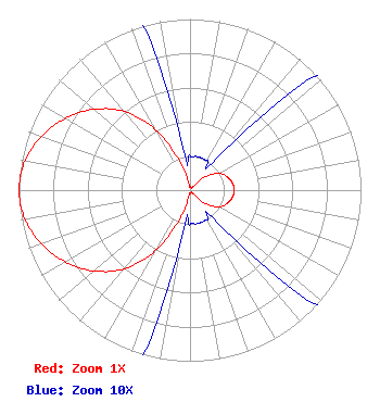 | ||||||||||||||||||
| Azimuth | Ratio | Azimuth | Ratio | Azimuth | Ratio | Azimuth | Ratio | ||||||||||||
| 0 | 0.020 | 10 | 0.020 | 20 | 0.020 | 30 | 0.020 | ||||||||||||
| 40 | 0.025 | 50 | 0.125 | 60 | 0.195 | 70 | 0.230 | ||||||||||||
| 80 | 0.250 | 90 | 0.260 | 100 | 0.250 | 110 | 0.230 | ||||||||||||
| 120 | 0.195 | 130 | 0.125 | 140 | 0.025 | 150 | 0.020 | ||||||||||||
| 160 | 0.020 | 170 | 0.020 | 180 | 0.020 | 190 | 0.030 | ||||||||||||
| 200 | 0.185 | 210 | 0.410 | 220 | 0.600 | 230 | 0.735 | ||||||||||||
| 240 | 0.840 | 250 | 0.923 | 260 | 0.980 | 270 | 1.000 | ||||||||||||
| 280 | 0.980 | 290 | 0.923 | 300 | 0.840 | 310 | 0.735 | ||||||||||||
| 320 | 0.600 | 330 | 0.410 | 340 | 0.185 | 350 | 0.030 | ||||||||||||
Structure Registration Number 1065467 Structure Type: TOWER Registered To: Commercial Radio & Television, Inc. dba: Frontier Radio, Inc. Structure Address: Frenchman Sunrise Mountain Las Vegas, NV County Name: Clark County ASR Issued: 07/09/2021 Date Built: 01/01/1998 Site Elevation: 1229 m (4032 ft.) Structure Height: 19.8 m (65 ft.) Height Overall: 25.9 m (85 ft.) Overall Height AMSL: 1254.9 m (4117 ft.) FAA Determination: 03/11/2006 FAA Study #: 2006-AWP-927-OE Paint & Light FAA Chapters: NONE Removed expiration date from determination. Scenario 1./jjs/case#635066 36-10-37.0 N 114-59-55.1 W (NAD 83) 36-10-37.1 N 114-59-52.1 W (Converted to NAD 27) |
4002 N. 3300 E. Twin Falls, ID 83301 Phone: 208-734-6633 Not-for-Profit | Date: 04/16/2014 Application Certifier CALVARY CHAPEL OF TWIN FALLS, INC. Po Box 391 Twin Falls, ID 83301 Applicant LOIS MILLS Po Box 391 Twin Falls, ID 83303 APPLICATION TECHNICIAN CARY TEPPER Tepper Law Firm, Llc 4900 Auburn Avenue, Suite 100 Bethesda, MD 20814-2632 | |||||||||||||||||