
FCCInfo.com
A Service of Cavell, Mertz & Associates, Inc.
(855) FCC-INFO
|
|
W255CJ from 06/21/2011 W255CJ from 12/08/2010 W255CJ from 07/20/2009 W255CJ from 06/02/2009 W255CJ from 12/03/2008 W255CJ from 11/30/2006 W255CJ from 06/30/2004 |
|
|
||||||||||||||||
|
|
W255CJ Channel: 255D 98.9 MHz Atlanta, Georgia Service: FX - A translator or application for a translator. Facility ID: 148550 Fac. Service: FX Programming Delivery Method: Unspecified Status: License Application Accepted: 02/08/2019 Application Granted: 02/21/2019 File Number: BLFT-20190208ABP License Expires: 00/00/0000 Prefix Type: This is a license for a translator Application Type: License To Cover FCC Website Links: LMS Facility Details This Application CDBS Application Other W255CJ Applications Other W255CJ Applications in CDBS Including Superseded Applications Mailing Address Correspondence for W255CJ Correspondence related to application BLFT-20190208ABP Service Contour - Open Street Map or USGS Map (60 dBu) Service Contour - KML / Google Earth (60 dBu) Class: D, A Noncommercial educational operating with no more than 10W Site Location: 33-48-26.4 N 84-20-21.7 W (NAD 83) Site Location: 33-48-26.0 N 84-20-22.0 W (Converted to NAD 27) Effective Radiated Power: 0.144 kW Transmitter Output Power: 0.452 kW Antenna Center HAAT: 301 m (988 ft.) Antenna Center AMSL: 588 m (1929 ft.) Antenna Center HAG: 324 m (1063 ft.) Site Elevation: 264 m. (866 ft.) Height Overall*: 360 m (1181 ft.) (* As Filed In This Application, may differ from ASR Data, Below.) Directional Antenna Antenna Make/Model: None Antenna ID: 134388 Polarization:
| ||||||||||||||||||
| Antenna Data for Antenna Id: 134388 W255CJ FX File: BLFT-20190208ABP None - Service: FX | 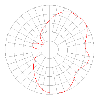 | ||||||||||||||||||
| Azimuth | Ratio | Azimuth | Ratio | Azimuth | Ratio | Azimuth | Ratio | ||||||||||||
| 0 | 0.656 | 10 | 0.790 | 20 | 0.896 | 30 | 0.967 | ||||||||||||
| 40 | 0.971 | 50 | 1.000 | 60 | 0.970 | 70 | 0.886 | ||||||||||||
| 80 | 0.814 | 90 | 0.814 | 100 | 0.903 | 110 | 0.898 | ||||||||||||
| 120 | 0.818 | 130 | 0.772 | 140 | 0.859 | 150 | 0.939 | ||||||||||||
| 160 | 0.995 | 170 | 0.985 | 180 | 0.965 | 190 | 0.906 | ||||||||||||
| 200 | 0.796 | 210 | 0.665 | 220 | 0.555 | 230 | 0.460 | ||||||||||||
| 240 | 0.370 | 250 | 0.255 | 260 | 0.194 | 270 | 0.220 | ||||||||||||
| 280 | 0.387 | 290 | 0.402 | 300 | 0.267 | 310 | 0.169 | ||||||||||||
| 320 | 0.301 | 330 | 0.407 | 340 | 0.472 | 350 | 0.551 | ||||||||||||
Structure Registration Number 1223132 Structure Type: GTOWER Registered To: American Towers LLC Structure Address: 1800 Briarcliff Road Ne (#282650) Atlanta, GA County Name: DeKalb County ASR Issued: 07/11/2023 Date Built: 03/27/2002 Site Elevation: 264.3 m (867 ft.) Structure Height: 321.9 m (1056 ft.) Height Overall: 360.3 m (1182 ft.) Overall Height AMSL: 624.6 m (2049 ft.) FAA Determination: 11/02/2021 FAA Study #: 2021-ASO-36490-OE FAA Circular #: 70/7460-1M Paint & Light FAA Chapters: 4, 9, 15 33-48-26.4 N 84-20-21.5 W (NAD 83) 33-48-26.0 N 84-20-21.8 W (Converted to NAD 27) |
3280 Peachtree Road, Nw Suite 2200 Atlanta, GA 30305 Phone: 404-949-0700 | Date: 02/08/2019 Application Certifier CUMULUS LICENSING LLC 3280 Peachtree Road, Nw Suite 2200 Atlanta, GA 30305 Applicant CHARLES M. ANDERSON Anderson Communications, Lcc 1519 Euclid Avenue Bowling Green, KY 42103 ENGINEERING CONSULTANT ANDREW S. KERSTING, ESQ. Cumulus Media Inc. 3280 Peachtree Road, Nw Suite 2200 Atlanta, GA 30305 | |||||||||||||||||