
FCCInfo.com
A Service of Cavell, Mertz & Associates, Inc.
(855) FCC-INFO
|
|
K223CT from 11/22/2013 |
|
|
||||||||||||||||
|
|
K223CT Channel: 223D 92.5 MHz San Antonio, Texas Service: FX - A translator or application for a translator. Facility ID: 147322 Fac. Service: FX Programming Delivery Method: Unspecified Status: License Application Accepted: 09/12/2017 Application Granted: 09/25/2017 File Number: BLFT-20170912AAM License Expires: 00/00/0000 Prefix Type: This is a license for a translator Application Type: License To Cover FCC Website Links: LMS Facility Details This Application CDBS Application Other K223CT Applications Other K223CT Applications in CDBS Including Superseded Applications Mailing Address Correspondence for K223CT Correspondence related to application BLFT-20170912AAM Service Contour - Open Street Map or USGS Map (60 dBu) Service Contour - KML / Google Earth (60 dBu) Class: D, A Noncommercial educational operating with no more than 10W Site Location: 29-17-24.9 N 98-15-21.0 W (NAD 83) Site Location: 29-17-24.0 N 98-15-20.0 W (Converted to NAD 27) Effective Radiated Power: 0 kW Horiz. ; 0.25 kW Vert. Transmitter Output Power: 0.122 kW Antenna Center HAAT: 0 m Antenna Center AMSL: 0 m Horiz.; 439 m Vert. Antenna Center HAG: 0 m Horiz.; 274 m Vert. Site Elevation: 165 m. (541 ft.) Height Overall*: 336 m (1102 ft.) (* As Filed In This Application, may differ from ASR Data, Below.) Directional Antenna Antenna Make/Model: None Antenna ID: 124497 Polarization:
| ||||||||||||||||||
| Antenna Data for Antenna Id: 124497 K223CT FX File: BLFT-20170912AAM None - Service: FX | 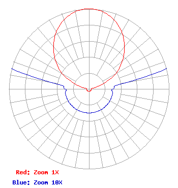 | ||||||||||||||||||
| Azimuth | Ratio | Azimuth | Ratio | Azimuth | Ratio | Azimuth | Ratio | ||||||||||||
| 0 | 1.000 | 10 | 0.980 | 20 | 0.916 | 30 | 0.817 | ||||||||||||
| 40 | 0.690 | 50 | 0.544 | 60 | 0.390 | 70 | 0.190 | ||||||||||||
| 80 | 0.050 | 90 | 0.030 | 100 | 0.030 | 110 | 0.030 | ||||||||||||
| 120 | 0.030 | 130 | 0.030 | 140 | 0.030 | 150 | 0.030 | ||||||||||||
| 160 | 0.030 | 170 | 0.030 | 180 | 0.030 | 190 | 0.030 | ||||||||||||
| 200 | 0.030 | 210 | 0.030 | 220 | 0.030 | 230 | 0.030 | ||||||||||||
| 240 | 0.030 | 250 | 0.030 | 260 | 0.030 | 270 | 0.030 | ||||||||||||
| 280 | 0.050 | 290 | 0.190 | 300 | 0.390 | 310 | 0.544 | ||||||||||||
| 320 | 0.690 | 330 | 0.817 | 340 | 0.916 | 350 | 0.980 | ||||||||||||
Structure Registration Number 1228187 Structure Type: TOWER Registered To: San Antonio Community Educational TV, Inc. Structure Address: Ene Intersection Of Sr 1604 And 181 Elmendorf, TX County Name: Wilson County ASR Issued: 11/04/2009 Date Built: 09/12/2002 Site Elevation: 164.6 m (540 ft.) Structure Height: 335.2 m (1100 ft.) Height Overall: 336.2 m (1103 ft.) Overall Height AMSL: 500.8 m (1643 ft.) FAA Determination: 06/26/2001 FAA Study #: 01-ASW-2036-OE FAA Circular #: 70/7460-1K Paint & Light FAA Chapters: 4, 7, 12 Removed expiration and final dates from determination. Scenario 2./jjs/case#635066 29-17-24.9 N 98-15-21.0 W (NAD 83) 29-17-24.0 N 98-15-20.0 W (Converted to NAD 27) |
1302 North Shepherd Drive Houston, TX 77008 Phone: 713-868-5559 Corporation | Date: 09/12/2017 Application Certifier SIGA BROADCASTING CORPORATION 1302 N. Shepherd Dr. Houston, TX 77008 Applicant CHARLES W. STAPLES 4424 Glenwick Lane University Park, TX 75205-1037 TECHNICAL CONSULTANT GABRIEL ARANGO Siga Broadcasting Corporation 1302 N. Shepherd Dr. Houston, TX 77008 | |||||||||||||||||