
FCCInfo.com
A Service of Cavell, Mertz & Associates, Inc.
(855) FCC-INFO
|
|
|
|
|
||||||||||||||||
|
|
K210CH Channel: 210D 89.9 MHz Ventura, California Service: FX - A translator or application for a translator. Facility ID: 90441 Fac. Service: FX Programming Delivery Method: Unspecified Status: License Application Accepted: 10/16/2017 Application Granted: 10/25/2017 File Number: BLFT-20171016AEO License Expires: 00/00/0000 Prefix Type: This is a license for a translator Application Type: License To Cover FCC Website Links: LMS Facility Details This Application CDBS Application Other K210CH Applications Other K210CH Applications in CDBS Including Superseded Applications Mailing Address Correspondence for K210CH Correspondence related to application BLFT-20171016AEO Service Contour - Open Street Map or USGS Map (60 dBu) Service Contour - KML / Google Earth (60 dBu) Class: D, A Noncommercial educational operating with no more than 10W Site Location: 34-17-47.0 N 119-16-24.4 W (NAD 83) Site Location: 34-17-47.0 N 119-16-21.0 W (Converted to NAD 27) Effective Radiated Power: 0.01 kW Transmitter Output Power: 0.005 kW Antenna Center HAAT: 279 m (915 ft.) Antenna Center AMSL: 411 m (1348 ft.) Antenna Center HAG: 59 m (194 ft.) Site Elevation: 352 m. (1155 ft.) Height Overall*: 63 m (207 ft.) (* As Filed In This Application, may differ from ASR Data, Below.) Directional Antenna Antenna Make/Model: None Antenna ID: 121710 Polarization:
| ||||||||||||||||||
| Antenna Data for Antenna Id: 121710 K210CH FX File: BLFT-20171016AEO None - Service: FX Pattern and Field Values Include a 353° Clockwise Rotation | 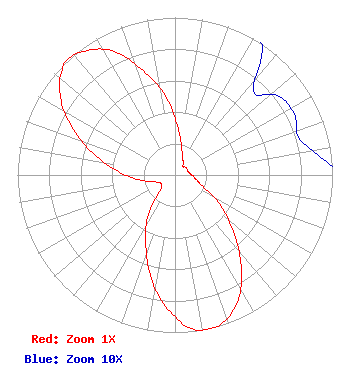 | ||||||||||||||||||
| Azimuth | Ratio | Azimuth | Ratio | Azimuth | Ratio | Azimuth | Ratio | ||||||||||||
| 3 | 0.313 | 13 | 0.186 | 23 | 0.118 | 33 | 0.102 | ||||||||||||
| 43 | 0.073 | 53 | 0.083 | 63 | 0.085 | 73 | 0.082 | ||||||||||||
| 83 | 0.093 | 93 | 0.115 | 103 | 0.141 | 113 | 0.195 | ||||||||||||
| 123 | 0.336 | 133 | 0.496 | 143 | 0.695 | 153 | 0.884 | ||||||||||||
| 163 | 0.992 | 168 | 1.000 | 173 | 0.991 | 183 | 0.854 | ||||||||||||
| 193 | 0.675 | 203 | 0.475 | 213 | 0.321 | 223 | 0.143 | ||||||||||||
| 233 | 0.109 | 243 | 0.109 | 253 | 0.145 | 263 | 0.236 | ||||||||||||
| 273 | 0.351 | 283 | 0.510 | 293 | 0.687 | 303 | 0.862 | ||||||||||||
| 313 | 0.981 | 318 | 1.000 | 323 | 0.978 | 333 | 0.886 | ||||||||||||
| 343 | 0.692 | 353 | 0.509 | ||||||||||||||||
Structure Registration Number 1014800 Structure Type: LTOWER Registered To: American Towers LLC Structure Address: (hall Canyon #89321--can) 3 Miles North Of East Main Ventura, CA County Name: Ventura County ASR Issued: 03/12/2015 Date Built: 12/28/1960 Site Elevation: 352.3 m (1156 ft.) Structure Height: 61 m (200 ft.) Height Overall: 63.1 m (207 ft.) Overall Height AMSL: 415.4 m (1363 ft.) FAA Determination: 02/23/2015 FAA Study #: 2015-AWP-1082-OE FAA Circular #: 70/7460-1K Paint & Light FAA Chapters: 4, 8, 12 Removed expiration date from determination. Scenario 1./jjs/case#635066 34-17-47.0 N 119-16-24.0 W (NAD 83) 34-17-47.0 N 119-16-20.6 W (Converted to NAD 27) |
18111 Nordhoff Street Northridge, CA 91330-8236 Phone: 818-677-4567 | Date: 10/16/2017 Application Certifier CALIFORNIA STATE UNIVERSITY NORTHRIDGE 18111 Nordhoff Street Northridge, CA 91330-8236 Applicant MICHAEL WORRALL 18111 Nordhoff Street Kcsn Radio Northridge, CA 91330-8312 CHIEF ENGINEER, KCSN RADIO SKY DANIELS California State University Northridge 18111 Nordhoff Street Northridge, CA 91330-8236 | |||||||||||||||||