
FCCInfo.com
A Service of Cavell, Mertz & Associates, Inc.
(855) FCC-INFO
|
|
KSAO-LD from 09/06/1999 KSAO-LD from 09/10/1998 KSAO-LD from 05/11/1998 KSAO-LD from 09/15/1997 KSAO-LD from 03/20/1997 KSAO-LD from 01/29/1992 |
|
|
||||||||||||||||
|
|
Status: License Application Accepted: 04/16/2020 License Expires: 12/01/2022 File Number: -0000112334 FCC Website Links: LMS Facility Details This Application Other KSAO-LD Applications Including Superseded Applications Mailing Address Correspondence for KSAO-LD Correspondence related to application -0000112334 Service Contour - Open Street Map or USGS Map (51 dBu) Service Contour - KML / Google Earth (51 dBu) Rabbit Ears Info Search for KSAO-LD Site Location: 38-38-53.0 N 121-05-54.3 W (NAD 83) Site Location: 38-38-53.3 N 121-05-50.5 W (Converted to NAD 27) ERP: 15 kW Polarization: Horizontally polarized R/C AGL: 27 m (89 ft.) R/C AMSL: 279.1 m (916 ft.) Emission Mask: Full Service Site Elevation: 252.1 m. (827 ft.) Height Overall*: 91.4 m (300 ft.) (* As Filed In This Application, may differ from ASR Data, Below.) Directional Antenna - Antenna Make/Model: Kathrein K72314 Antenna ID: 19753 Polarization: Horizontally polarized | ||||||||||||||||||
| Antenna Data for Antenna Id: 19753 KSAO-LD LD File: -0000112334 Kathrein - K72314 Service: LD Standard Pattern: Y Pattern and Field Values Include a 270° Clockwise Rotation | 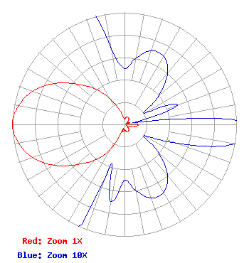 | ||||||||||||||||||
| Azimuth | Ratio | Azimuth | Ratio | Azimuth | Ratio | Azimuth | Ratio | ||||||||||||
| 0 | 0.050 | 10 | 0.060 | 20 | 0.070 | 30 | 0.070 | ||||||||||||
| 40 | 0.060 | 50 | 0.040 | 60 | 0.020 | 70 | 0.050 | ||||||||||||
| 80 | 0.010 | 90 | 0.120 | 100 | 0.100 | 110 | 0.050 | ||||||||||||
| 120 | 0.020 | 130 | 0.040 | 140 | 0.060 | 150 | 0.070 | ||||||||||||
| 160 | 0.070 | 170 | 0.060 | 180 | 0.050 | 190 | 0.070 | ||||||||||||
| 200 | 0.050 | 210 | 0.270 | 220 | 0.420 | 230 | 0.560 | ||||||||||||
| 240 | 0.730 | 250 | 0.870 | 260 | 0.960 | 270 | 1.000 | ||||||||||||
| 280 | 0.960 | 290 | 0.870 | 300 | 0.730 | 310 | 0.560 | ||||||||||||
| 320 | 0.420 | 330 | 0.270 | 340 | 0.150 | 350 | 0.070 | ||||||||||||
Structure Registration Number 1033381 Structure Type: GTOWER Registered To: American Towers LLC Structure Address: 1993 Caverham Way (8107 / El Dorado North T1 Ca) Folsom, CA County Name: Sacramento County ASR Issued: 12/21/2015 Date Built: 01/01/1993 Site Elevation: 252.1 m (827 ft.) Structure Height: 90.5 m (297 ft.) Height Overall: 91.4 m (300 ft.) Overall Height AMSL: 343.5 m (1127 ft.) FAA Determination: 11/30/2015 FAA Study #: 2015-AWP-11128-OE FAA Circular #: 70/7460-1K Paint & Light FAA Chapters: 3, 4, 5, 12 PRIOR STUDY 2013-AWP-52-OE 38-38-53.0 N 121-05-54.3 W (NAD 83) 38-38-53.3 N 121-05-50.5 W (Converted to NAD 27) |
38955 Hills Tech Dr. Farmington Hills, MI 48331 Phone: 248-536-0776 Limited Liability Company | Title: Sole Member And Manager Date: 04/16/2020 Application Certifier COCOLA BROADCASTING COMPANIES, LLC Cocola Broadcasting Companies, Llc 706 W. Herndon Avenue Fresno, CA 93650 Applicant Gregory Best Greg Best Consulting, Inc. 16100 Outlook Ave. Stilwell, KS 66085 Consulting Engineer MICHAEL COUZENS Michael Couzens Attorney At Law 6536 Telegraph Ave. Suite B201 Oakland, CA 94609 LEGAL REPRESENTATIVE JAMES K. ZAHN Cocola Broadcasting Companies, Llc 706 West Herndon Avenue Fresno, CA 93650 BROADCAST CONSULTANT | |||||||||||||||||