
FCCInfo.com
A Service of Cavell, Mertz & Associates, Inc.
(855) FCC-INFO
|
|
|
Virtual Channel 7 |  |
|
||||||||||||||||||||||||||||||||||||||||||||||||||||||||||||||||||||||||||||||||||||||||||||||||
|
|
Repacking Information: No changes Status: License Application Accepted: 08/09/2012 License Expires: 04/01/2022 File Number: BXLCDT-20120809AAX Prefix Type: This is BXLCDT FCC Website Links: LMS Facility Details This Application Other KMGH-TV Applications Including Superseded Applications Mailing Address Correspondence for KMGH-TV Correspondence related to application BXLCDT-20120809AAX Service Contour - Open Street Map or USGS Map (36 dBu) Service Contour - KML / Google Earth (36 dBu) Public Inspection Files History Cards for KMGH-TV Rabbit Ears Info Search for KMGH-TV Site Location: 39-43-50.6 N 105-13-55.6 W (NAD 83) Site Location: 39-43-50.6 N 105-13-53.6 W (Converted to NAD 27) ERP: 27 kW Polarization: Horizontally polarized HAAT: 257 m (843 ft.) Electrical Beam Tilt: 1 degree R/C AGL: 97.4 m (320 ft.) R/C AMSL: 2266.4 m (7436 ft.) Site Elevation: 2169 m. (7116 ft.) Height Overall*: 223.8 m (734 ft.) (* As Filed In This Application, may differ from ASR Data, Below.) Directional Antenna - Antenna Make/Model: DIELECTRIC DCBR-C3-4HA/12H1-S Antenna ID: 90733 Polarization: Horizontally polarized
| |||||||||||||||||||||||||||||||||||||||||||||||||||||||||||||||||||||||||||||||||||||||||||||||||||
| Antenna Data for Antenna Id: 90733 KMGH-TV DX File: BXLCDT-20120809AAX DIELECTRIC - DCBR-C3-4HA/12H1-S Service: DX Standard Pattern: Y | 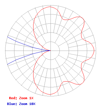 | |||||||||||||||||||||||||||||||||||||||||||||||||||||||||||||||||||||||||||||||||||||||||||||||||||
| Azimuth | Ratio | Azimuth | Ratio | Azimuth | Ratio | Azimuth | Ratio | |||||||||||||||||||||||||||||||||||||||||||||||||||||||||||||||||||||||||||||||||||||||||||||
| 0 | 0.959 | 10 | 0.898 | 20 | 0.752 | 30 | 0.782 | |||||||||||||||||||||||||||||||||||||||||||||||||||||||||||||||||||||||||||||||||||||||||||||
| 40 | 0.966 | 45 | 1.000 | 50 | 0.966 | 60 | 0.782 | |||||||||||||||||||||||||||||||||||||||||||||||||||||||||||||||||||||||||||||||||||||||||||||
| 70 | 0.752 | 80 | 0.898 | 90 | 0.959 | 100 | 0.898 | |||||||||||||||||||||||||||||||||||||||||||||||||||||||||||||||||||||||||||||||||||||||||||||
| 110 | 0.752 | 120 | 0.782 | 130 | 0.966 | 135 | 1.000 | |||||||||||||||||||||||||||||||||||||||||||||||||||||||||||||||||||||||||||||||||||||||||||||
| 140 | 0.966 | 150 | 0.782 | 160 | 0.752 | 170 | 0.898 | |||||||||||||||||||||||||||||||||||||||||||||||||||||||||||||||||||||||||||||||||||||||||||||
| 180 | 0.959 | 190 | 0.932 | 200 | 0.853 | 210 | 0.732 | |||||||||||||||||||||||||||||||||||||||||||||||||||||||||||||||||||||||||||||||||||||||||||||
| 220 | 0.581 | 230 | 0.418 | 240 | 0.261 | 250 | 0.128 | |||||||||||||||||||||||||||||||||||||||||||||||||||||||||||||||||||||||||||||||||||||||||||||
| 260 | 0.036 | 270 | 0.001 | 280 | 0.036 | 290 | 0.128 | |||||||||||||||||||||||||||||||||||||||||||||||||||||||||||||||||||||||||||||||||||||||||||||
| 300 | 0.261 | 310 | 0.418 | 320 | 0.581 | 330 | 0.732 | |||||||||||||||||||||||||||||||||||||||||||||||||||||||||||||||||||||||||||||||||||||||||||||
| 340 | 0.853 | 350 | 0.932 | |||||||||||||||||||||||||||||||||||||||||||||||||||||||||||||||||||||||||||||||||||||||||||||||||
Structure Registration Number 1058328 Structure Type: TOWER Registered To: LAKE CEDAR GROUP, L.L.C. Structure Address: Lookout Mountain, 21119 Cedar Lake Road, Jefferson County Golden, CO County Name: Jefferson County ASR Issued: 07/02/2008 Date Built: 06/01/2009 Site Elevation: 2168.8 m (7115 ft.) Structure Height: 189.1 m (620 ft.) Height Overall: 223.8 m (734 ft.) Overall Height AMSL: 2392.6 m (7850 ft.) FAA Determination: 07/01/2008 FAA Study #: 2008-ANM-2069-OE FAA Circular #: 70/7460-1K Paint & Light FAA Chapters: 3, 4, 5, 12 PRIOR STUDY 2001-ANM-3722-OE 39-43-50.6 N 105-13-55.6 W (NAD 83) 39-43-50.6 N 105-13-53.6 W (Converted to NAD 27) |
312 Walnut Street 28th Floor Cincinnati, OH 45202 Phone: 513-977-3000 Limited Liability Company | Date: 08/09/2012 Application Certifier SCRIPPS MEDIA, INC. 312 Walnut Street 28th Floor Cincinnati, OH 45202-4067 Applicant BENJAMIN L. PIDEK, P.E. Mid-state Consultants 1172 South M-13 Lennon, MI 48449 CONSULTING ENGINEER KENNETH C. HOWARD JR. Baker & Hostetler Llp 1050 Connecticut Avenue Suite 1100 Washington, DC 20036-5304 | ||||||||||||||||||||||||||||||||||||||||||||||||||||||||||||||||||||||||||||||||||||||||||||||||||
|
| |||||||||||||||||||||||||||||||||||||||||||||||||||||||||||||||||||||||||||||||||||||||||||||||||||
