|
|
Antenna Structure Registration 1004480 |
 |
Registration Info | Registration Number: 1004480 |
| File Number: A0732736 |
| FAA Study: 2010-ANM-45-OE |
| FAA Issue Date: 02/02/2010 |
| Status: Constructed |
| Date Constructed: 01/01/1995 |
| FAA EMI: N |
| NEPA: N |
Structure Info
| Structure Type: TOWER |
| Structure Coordinates: 48-10-33.9 N 114-21-0.2 W (NAD 83) |
| Structure Coordinates: 48-10-34.1 N 114-20-56.7 W (Converted to NAD 27) |
| Structure Address: Lone Pine Approx 2 Mi Sw |
| Structure City: Kalispell, MT |
| Structure County: Flathead County |
| Painting & Lighting Info |
FAA Circular #: 70/7460-1H |
FAA Chapters: 4, 5, 13 |
Remarks: OM&L to remain the same as prior study = RED LIGHTS |
Remarks: PRIOR STUDY 1994-ANM-976-OE |
Remarks: Removed expiration and final dates from determination. Scenario 2./jjs/case#635066 |
| Elevation Info |
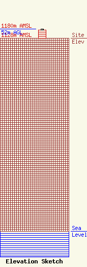
Site Elevation: 1128 meters (3701 ft) |
| Height of Structure: 46 meters (151 feet) |
| Overall Height Above Ground: 52 meters (171 feet) |
| Overall Height Above Mean Sea Level: 1180 meters (3871 feet) |
| Owner Info | WEESE, RAE SHIRLEEN DBA = WEESE ENTERPRISES
826
BIGFORK, MT 59911
(406) 837-4225
|
