|
|
Antenna Structure Registration 1213661 |
 |
Registration Info | Registration Number: 1213661 |
| File Number: A0176729 |
| FAA Study: 00-AGL-0413-OE |
| FAA Issue Date: 03/20/2000 |
| Status: Constructed |
| Date Constructed: 01/01/1954 |
| FAA EMI: N |
| NEPA: N |
Structure Info
| Structure Type: TOWER |
| Structure Coordinates: 48-6-37.7 N 103-26-38.3 W (NAD 83) |
| Structure Coordinates: 48-06-37.6 N 103-26-36.6 W (Converted to NAD 27) |
| Structure Address: 6mi East And 3 Mi So Of Williston |
| Structure City: Williston, ND |
| Structure County: Williams County |
| Painting & Lighting Info |
FCC Paragraph(s): 1, 3, 11, 21 |
Remarks: PRIOR FAA 78-RM-0254-OE CONTINUE OM&L PAINT/RED LIGHTS |
| Elevation Info |
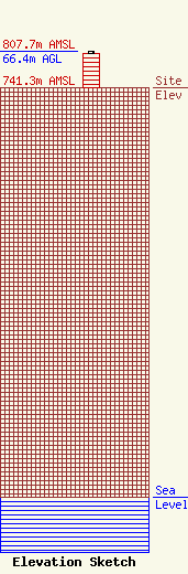
Site Elevation: 741.3 meters (2432 ft) |
| Height of Structure: 61 meters (200 feet) |
| Overall Height Above Ground: 66.4 meters (218 feet) |
| Overall Height Above Mean Sea Level: 807.7 meters (2650 feet) |
| Owner Info | Kohler Communications of Williston Inc
14012 WEST FRONT ST
Williston, ND 58801
(701) 774-8596
kohwill@ruggedwest.com |
