|
|
Antenna Structure Registration 1024656 |
 |
Registration Info | Registration Number: 1024656 |
| File Number: A1108830 |
| FAA Study: 99-ANM-0110-OE |
| FAA Issue Date: 03/31/1999 |
| Status: Constructed |
| Date Constructed: 04/01/1999 |
| NEPA: N |
Structure Info
|
| Structure Coordinates: 39-17-41.0 N 102-15-39.0 W (NAD 83) |
| Structure Coordinates: 39-17-41.0 N 102-15-37.3 W (Converted to NAD 27) |
| Structure Address: 17543 Cr 49 |
| Structure City: Burlington, CO |
| Structure County: Kit Carson County |
| Painting & Lighting Info |
FAA Chapters: NONE |
| Elevation Info |
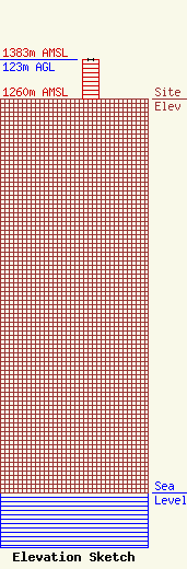
Site Elevation: 1260 meters (4134 ft) |
| Height of Structure: 123 meters (404 feet) |
| Overall Height Above Ground: 123 meters (404 feet) |
| Overall Height Above Mean Sea Level: 1383 meters (4537 feet) |
| Owner Info | KNAB INC
17543 CR 49
17543 CR 49
BURLINGTON, CO 80807
(719) 346-8600
alec@necolorado.com |
| Contact Info | KNAB INC
17543 CR 49
17543 CR 49
BURLINGTON, CO 80807
(719) 346-8600
alec@necolorado.com |
