|
|
Antenna Structure Registration 1051945 |
 |
Registration Info | Registration Number: 1051945 |
| File Number: A0061199 |
| FAA Study: 97-ASW-0081-OE |
| FAA Issue Date: 01/08/1997 |
| Status: Constructed |
| Date Constructed: 01/01/1983 |
| NEPA: N |
Structure Info
| Structure Type: TOWER |
| Structure Coordinates: 33-37-10.0 N 95-32-51.0 W (NAD 83) |
| Structure Coordinates: 33-37-09.6 N 95-32-50.2 W (Converted to NAD 27) |
| Structure Address: 1.6 Km S Of S Loop 286 On Cr 11300 |
| Structure City: Paris, TX |
| Structure County: Lamar County |
| Painting & Lighting Info |
FAA Circular #: 70/7460-1H |
FAA Chapters: 3, 4, 5, 13 |
| Elevation Info |
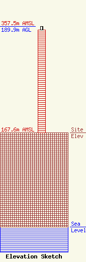
Site Elevation: 167.6 meters (550 ft) |
| Height of Structure: 183.8 meters (603 feet) |
| Overall Height Above Ground: 189.9 meters (623 feet) |
| Overall Height Above Mean Sea Level: 357.5 meters (1173 feet) |
| Owner Info | AIRWAVES COMMUNICATIONS INC
4801 LAMAR AVE
PARIS, TX 75462-7410
(903) 785-8881
AIRWAVES@NETO.COM |
