|
|
Antenna Structure Registration 1041652 |
 |
Registration Info | Registration Number: 1041652 |
| File Number: A1100341 |
| FAA Study: 92-AGL-1465-OE |
| FAA Issue Date: 09/14/1992 |
| Status: Constructed |
| Date Constructed: 06/19/1996 |
| NEPA: N |
Structure Info
| Structure Type: TOWER |
| Structure Coordinates: 45-27-57.0 N 98-20-9.0 W (NAD 83) |
| Structure Coordinates: 45-27-57.1 N 98-20-07.7 W (Converted to NAD 27) |
| Structure Address: .25 Mi W |
| Structure City: Bath, SD |
| Structure County: Brown County |
| Painting & Lighting Info |
FAA Circular #: 70/7460-1H |
FAA Chapters: 3, 4, 5, 13 |
Remarks: RED LIGHTS/PAINT |
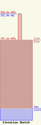
| Elevation Info |
Site Elevation: 397.2 meters (1303 ft) |
| Height of Structure: 150.6 meters (494 feet) |
| Overall Height Above Ground: 152.4 meters (500 feet) |
| Overall Height Above Mean Sea Level: 549.6 meters (1803 feet) |
| Owner Info | Northern Electric Cooperative
39456 133rd St
547
Bath, SD 57427
(605) 225-0310
dgorecki@northernelectric.coop |
| Contact Info | Northern Electric Cooperative
39456 133rd St
547
Bath, SD 57427
Derek Gorecki
(605) 225-0310
dgorecki@northernelectric.coop |
