|
|
Antenna Structure Registration 1227632 |
 |
Registration Info | Registration Number: 1227632 |
| File Number: A1243534 |
| FAA Study: 2023-AGL-3332-OE |
| FAA Issue Date: 04/28/2023 |
| Status: Constructed |
| Date Constructed: 07/30/2002 |
| NEPA: N |
Structure Info
| Structure Type: GTOWER |
| Structure Coordinates: 46-17-41.1 N 96-6-0.2 W (NAD 83) |
| Structure Coordinates: 46-17-41.2 N 96-05-59.0 W (Converted to NAD 27) |
| Structure Address: 1003 Progress Dr. |
| Structure City: Fergus Falls, MN |
| Structure County: Otter Tail County |
| Painting & Lighting Info |
FAA Chapters: NONE |
Remarks: PRIOR STUDY 2015-AGL-8429-OE |
| Elevation Info |
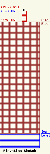
Site Elevation: 377 meters (1237 ft) |
| Height of Structure: 36.6 meters (120 feet) |
| Overall Height Above Ground: 42.7 meters (140 feet) |
| Overall Height Above Mean Sea Level: 419.7 meters (1377 feet) |
| Owner Info | Tarpon Towers II, LLC
8916 77th Terrace East
Lakewood Ranch, FL 34202
(941) 757-5010
tbowman@tarpontowers.com |
| Contact Info | Tarpon Towers II, LLC
8916 77th Terrace East
Lakewood Ranch, FL 34202
Todd Bowman
(941) 757-5010
tbowman@tarpontowers.com |
