|
|
Antenna Structure Registration 1042070 |
 |
Registration Info | Registration Number: 1042070 |
| File Number: A0049605 |
| Status: Constructed |
| Date Constructed: 01/01/1956 |
| NEPA: N |
Structure Info
| Structure Type: TOWER |
| Structure Coordinates: 40-32-36.0 N 112-18-36.0 W (NAD 83) |
| Structure Coordinates: 40-32-36.2 N 112-18-33.2 W (Converted to NAD 27) |
| Structure Address: 600 N 400 W |
| Structure City: Tooele, UT |
| Structure County: Tooele County |
| Painting & Lighting Info |
FCC Paragraph(s): 1, 3, 11, 21 |
| Elevation Info |
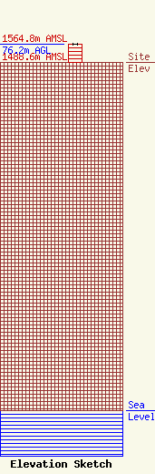
Site Elevation: 1488.6 meters (4884 ft) |
| Height of Structure: 75.6 meters (248 feet) |
| Overall Height Above Ground: 76.2 meters (250 feet) |
| Overall Height Above Mean Sea Level: 1564.8 meters (5134 feet) |
| Owner Info | WINEGAR, WENDELL T:WINEGAR, ELAINE K DBA = WINEGARS RENTALS REPAIR & STORAGE
5190 W 2600 N
PLAIN CITY, UT 84404
(801) 731-4700
|
