|
|
Antenna Structure Registration 1252762 |
 |
Registration Info | Registration Number: 1252762 |
| File Number: A1150595 |
| FAA Study: 2006-ACE-228-OE |
| FAA Issue Date: 03/10/2006 |
| Status: Constructed |
| Date Constructed: 02/06/2007 |
| FAA EMI: N |
| NEPA: N |
Structure Info
| Structure Type: TOWER |
| Structure Coordinates: 38-2-57.2 N 98-0-45.2 W (NAD 83) |
| Structure Coordinates: 38-02-57.2 N 98-00-44.0 W (Converted to NAD 27) |
| Structure Address: 5 Miles West Of City |
| Structure City: Hutchinson, KS |
| Structure County: Reno County |
| Painting & Lighting Info |
FAA Circular #: 70/7460-1K |
FAA Chapters: 4, 8, 12 |
Remarks: Removed expiration date from determination. Scenario 1./jjs/case#635066 |
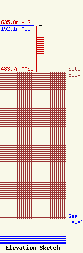
| Elevation Info |
Site Elevation: 483.7 meters (1587 ft) |
| Height of Structure: 151.2 meters (496 feet) |
| Overall Height Above Ground: 152.1 meters (499 feet) |
| Overall Height Above Mean Sea Level: 635.8 meters (2086 feet) |
| Owner Info | K2 Towers II, LLC
57 E. Washington Street
Chagrin Falls, OH 44022
(440) 528-0333
rlepene@k2towers.com |
| Contact Info | K2 Towers II, LLC
57 E. Washington Street
Chagrin Falls, OH 44022
Greg Thompson
(440) 528-0333
gthompson@k2towers.com |
