|
|
Antenna Structure Registration 1004619 |
 |
Registration Info | Registration Number: 1004619 |
| File Number: A0548475 |
| FAA Study: 97-ASW-0229-OE |
| FAA Issue Date: 02/20/1997 |
| Status: Constructed |
| Date Constructed: 01/01/1982 |
| FAA EMI: N |
| NEPA: N |
Structure Info
| Structure Type: TOWER |
| Structure Coordinates: 34-26-23.0 N 103-12-46.0 W (NAD 83) |
| Structure Coordinates: 34-26-22.7 N 103-12-44.2 W (Converted to NAD 27) |
| Structure Address: Approximately 6 Km N Post Office |
| Structure City: Clovis, NM |
| Structure County: Curry County |
| Painting & Lighting Info |
FAA Circular #: 70/7460-1J |
FAA Chapters: 3, 4, 5, 13 |
Remarks: Removed expiration date from determination. Scenario 1./jjs/case#635066 |
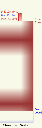
| Elevation Info |
Site Elevation: 1316.7 meters (4320 ft) |
| Height of Structure: 108.5 meters (356 feet) |
| Overall Height Above Ground: 110.6 meters (363 feet) |
| Overall Height Above Mean Sea Level: 1427.3 meters (4683 feet) |
| Owner Info | KOB-TV, LLC
3415 UNIVERSITY AVENUE, WEST
ST. PAUL, MN 55114-2009
(651) 642-4334
DJONES@HBI.COM |
| Contact Info | HUBBARD BROADCASTING, INC.
3415 UNIVERSITY AVENUE, WEST
ST. PAUL, MN 55114-2009
DAVID JONES
(651) 642-4334
DJONES@HBI.COM |
