|
|
Antenna Structure Registration 1269082 |
 |
Registration Info | Registration Number: 1269082 |
| File Number: A0654795 |
| FAA Study: 2009-ANM-1199-OE |
| FAA Issue Date: 07/15/2009 |
| Status: Constructed |
| Date Constructed: 05/20/2009 |
| FAA EMI: N |
| NEPA: N |
Structure Info
| Structure Type: TOWER |
| Structure Coordinates: 46-6-13.9 N 119-7-44.5 W (NAD 83) |
| Structure Coordinates: 46-06-14.4 N 119-07-40.5 W (Converted to NAD 27) |
| Structure Address: 7 Miles South Of Kennewick, Washington Ontop Of Jump Off Joe Butte |
| Structure City: Kennewick, WA |
| Structure County: Benton County |
| Painting & Lighting Info |
FAA Chapters: NONE |
Remarks: PRIOR STUDY 2001-ANM-694-OE |
| Elevation Info |
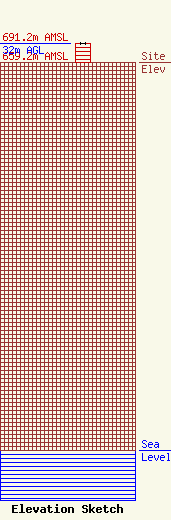
Site Elevation: 659.2 meters (2163 ft) |
| Height of Structure: 32 meters (105 feet) |
| Overall Height Above Ground: 32 meters (105 feet) |
| Overall Height Above Mean Sea Level: 691.2 meters (2268 feet) |
| Owner Info | Day Wireless Systems
4700 SE International Way
22169
Milwaukie, OR 97222
(503) 659-1240
dballew@daywireless.com |
| Contact Info | Day Wireless Systems
4700 SE International Way
22169
Milwaukie, OR 97222
Dean Ballew
(503) 659-1240
dballew@daywireless.com |
