|
|
Antenna Structure Registration 1233113 |
 |
Registration Info | Registration Number: 1233113 |
| File Number: A1181793 |
| FAA Study: 87-ASW-0871-OE |
| FAA Issue Date: 06/03/1987 |
| Status: Terminated |
| Date Constructed: 07/25/1987 |
| FAA EMI: N |
| NEPA: N |
Structure Info
|
| Structure Coordinates: 34-13-22.2 N 103-17-7.8 W (NAD 83) |
| Structure Coordinates: 34-13-21.9 N 103-17-06.0 W (Converted to NAD 27) |
| Structure Address: 3.8 Mi. N. On Hwy. 70 From Portales At Portales City Water Tanks |
| Structure City: Portales, NM |
| Structure County: Roosevelt County |
| Painting & Lighting Info |
FCC Paragraph(s): 1, 3, 11, 21 |
Remarks: RED LIGHTS/PAINT |
| Elevation Info |
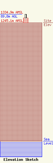
Site Elevation: 1245.1 meters (4085 ft) |
| Height of Structure: 50.2 meters (165 feet) |
| Overall Height Above Ground: 89.8 meters (295 feet) |
| Overall Height Above Mean Sea Level: 1334.9 meters (4380 feet) |
| Owner Info | American Towers LLC
10 Presidential Way
Woburn, MA 01801
(781) 926-4500
faa-fcc@americantower.com |
| Contact Info | American Towers LLC
10 Presidential Way
Woburn, MA 01801
(781) 926-4500
faa-fcc@americantower.com |
