|
|
Antenna Structure Registration 1060388 |
 |
Registration Info | Registration Number: 1060388 |
| File Number: A0707508 |
| FAA Study: 88-AWP-689-OE |
| FAA Issue Date: 07/29/1988 |
| Status: Constructed |
| Date Constructed: 01/01/1960 |
| FAA EMI: N |
| NEPA: N |
Structure Info
| Structure Type: TOWER |
| Structure Coordinates: 39-43-37.0 N 121-40-49.0 W (NAD 83) |
| Structure Coordinates: 39-43-37.4 N 121-40-45.1 W (Converted to NAD 27) |
| Structure Address: 3.8 Mi W On Skyway |
| Structure City: Paradise, CA |
| Structure County: Butte County |
| Painting & Lighting Info |
FAA Circular #: 70/7460-1G |
FAA Chapters: 3, 4, 5, 9 |
| Elevation Info |
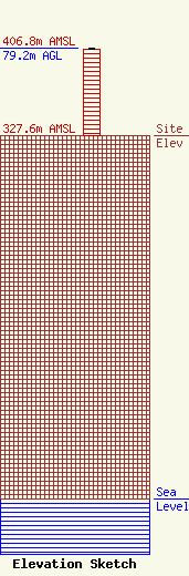
Site Elevation: 327.6 meters (1075 ft) |
| Height of Structure: 78.3 meters (257 feet) |
| Overall Height Above Ground: 79.2 meters (260 feet) |
| Overall Height Above Mean Sea Level: 406.8 meters (1335 feet) |
| Owner Info | BUTTE BROADCASTING COMPANY INC DBA = KKXX AM
3185 South Highland Drive, Suite 13
Las Vegas, NV 89109-1029
(702) 731-5588
cauel@gate.net |
