|
|
Antenna Structure Registration 1206727 |
 |
Registration Info | Registration Number: 1206727 |
| File Number: A1383528 |
| FAA Study: 99-ASW-3870-OE |
| FAA Issue Date: 11/17/1999 |
| Status: Constructed |
| Date Constructed: 02/03/1995 |
| FAA EMI: N |
| NEPA: N |
Structure Info
| Structure Type: TOWER |
| Structure Coordinates: 36-4-6.4 N 90-37-58.1 W (NAD 83) |
| Structure Coordinates: 36-04-06.2 N 90-37-57.7 W (Converted to NAD 27) |
| Structure Address: 333 Greene 712 Rd |
| Structure City: Paragould, AR |
| Structure County: Greene County |
| Painting & Lighting Info |
FAA Circular #: 70/7460-1J |
FAA Chapters: 4, 6, 13 |
Remarks: Removed expiration date from determination. Scenario 1./jjs/case#635066 |
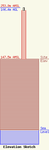
| Elevation Info |
Site Elevation: 147.5 meters (484 ft) |
| Height of Structure: 100.6 meters (330 feet) |
| Overall Height Above Ground: 106.4 meters (349 feet) |
| Overall Height Above Mean Sea Level: 253.9 meters (833 feet) |
| Owner Info | WE Holdings I, LLC
57 E Washington Street
Chagrin Falls, OH 44022
(866) 962-0904
rlepene@peppertreecapital.com |
| Contact Info | WE Holdings I, LLC
57 E Washington Street
Chagrin Falls, OH 44022
Greg Thompson
(866) 962-0904
gthompson@k2towers.com |
