|
|
Antenna Structure Registration 1003647 |
 |
Registration Info | Registration Number: 1003647 |
| File Number: A1305739 |
| FAA Study: 88-ACE-0359-OE |
| Status: Constructed |
| Date Constructed: 07/01/1990 |
| FAA EMI: N |
| NEPA: N |
Structure Info
| Structure Type: TOWER |
| Structure Coordinates: 37-10-30.0 N 93-2-36.0 W (NAD 83) |
| Structure Coordinates: 37-10-29.8 N 93-02-35.4 W (Converted to NAD 27) |
| Structure Address: 700 Meters Sw Of Int Rt B With Rt Kk Approx 6.4 Km N |
| Structure City: Rogersville, MO |
| Structure County: Webster County |
| Painting & Lighting Info |
FAA Circular #: 70/7460-1G |
FAA Chapters: 4, 6, 9 |
| Elevation Info |
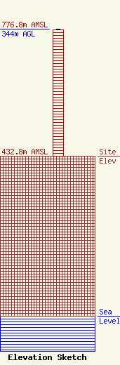
Site Elevation: 432.8 meters (1420 ft) |
| Height of Structure: 341.4 meters (1120 feet) |
| Overall Height Above Ground: 344 meters (1129 feet) |
| Overall Height Above Mean Sea Level: 776.8 meters (2549 feet) |
| Owner Info | GTC Uno, LLC
865
Rancho Cordova, CA 95741
(844) 482-8977
lkirth@gtctowers.com |
| Contact Info | GTC Uno, LLC
865
Rancho Cordova, CA 95741
Lucy Kirth
(844) 482-8977
lkirth@gtctowers.com |
