|
|
Antenna Structure Registration 1011845 |
 |
Registration Info | Registration Number: 1011845 |
| File Number: A1219285 |
| FAA Study: 2022-ASW-12457-OE |
| FAA Issue Date: 06/22/2022 |
| Status: Constructed |
| Date Constructed: 05/31/1982 |
| NEPA: N |
Structure Info
| Structure Type: GTOWER |
| Structure Coordinates: 36-24-7.4 N 99-25-43.8 W (NAD 83) |
| Structure Coordinates: 36-24-07.3 N 99-25-42.4 W (Converted to NAD 27) |
| Structure Address: 2 Mi S Of 34th St & Hwy 412 1/8 Mi W S Into |
| Structure City: Woodward, OK |
| Structure County: Woodward County |
| Painting & Lighting Info |
FAA Circular #: 70/7460-1M |
FAA Chapters: 4, 8, 15 |
Remarks: PRIOR STUDY 1983-ASW-2715-OE |
| Elevation Info |
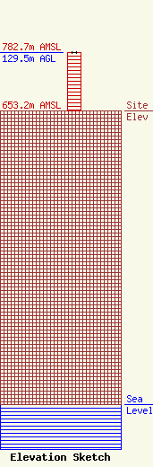
Site Elevation: 653.2 meters (2143 ft) |
| Height of Structure: 129.5 meters (425 feet) |
| Overall Height Above Ground: 129.5 meters (425 feet) |
| Overall Height Above Mean Sea Level: 782.7 meters (2568 feet) |
| Owner Info | G AND G ELECTRONICS, INC.
102 NORTH MAIN STREET
GUYMON, OK 73942
(580) 338-7763
ggelecg@gmail.com |
| Contact Info | G AND G ELECTRONICS, INC.
102 NORTH MAIN STREET
73942
GUYMON, OK 73942
(580) 338-7763
ggelecg@gmail.com |
